National Howl-iday Scene: Part I

Tavish with the 2012 Capitol tree


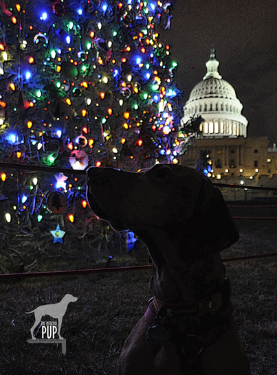
GO FIGURE:  Intrepid Pup particularly liked the theme for the 2012 Capitol tree: “The Great Outdoors”! Culled from the White River National Forest in Colorado, this 74-year-old Engelmann spruce made stops in 30 different towns en route to Washington, DC. The tour was sponsored in part by Choose Outdoors, an organization dedicated to connecting Americans to public lands through outdoor recreation. The tree stands 73 feet tall and is laden with approximately 3,000 ornaments, most of which were handmade by Colorado schoolchildren.

With the holiday season comes an explosion of colorful decorations. Elaborate displays crop up in downtowns across America, and for a few short weeks everything takes on the magical luster that only twinkle lights can impart. The Washington, DC metro area is particularly picturesque in December, and the weather is usually still temperate enough that touring around is not a completely frigid proposition.

Over the next several posts, Tavish the Intrepid Pup will give you an insider’s tour of the national “howl-iday” scene, scoping out what are arguably among the most iconic—and dog-friendly—holiday spots the capital region has to offer.

*  *  *

Tavish’s first destination is the 2012 Christmas Tree on the grounds of the United States Capitol.

The original Capitol Christmas tree was a Douglas fir specifically planted on the property in 1964 to fulfill that role. When it eventually succumbed to storm damage, the Architect of the Capitol enlisted the help of the U.S. Department of Agriculture’s Forest Service to sustain the holiday tradition. Every year since 1970, the trees destined for Capitol Hill have been cut and harvested from various national forests. Citizens from the home state supply thousands of handcrafted ornaments showcasing aspects of their state’s heritage, earning the Capitol tree the apt designation as the “People’s Tree.”

Click to see what a 3 on the Wag-A-Meter meansDogging the Details

38°53′23.24″N, 77°0′40.19″W
United States Capitol Christmas Tree, Washington, DC

The 2012 tree is on view December 4 – 26, 2012.

While the Capitol tree is one of Team Tavish‘s favorites in the metro DC region, it’s also the most fleeting. The cut tree arrives shortly after Thanksgiving and takes a little more than a week to be secured and decorated before a public tree-lighting ceremony with the Architect of the Capitol and the Speaker of the House in early December.  Thereafter, the tree is illuminated nightly from dusk to 11 pm until shortly after Christmas.

Timed parking on the street and in nearby surface lots makes the Capitol tree readily accessible during the evening hours. The large West Lawn can accommodate a LOT of people before ever seeming crowded, and that truly distinguishes this setting from some of the others on the “howl-iday scene.”  You can get right up close to the tree without being rushed or jostled, and that makes it great for checking out the diversity and creativity of the decorations. This year’s tree is an Engelmann spruce from Colorado, so many of the ornaments depict Colorado wildlife, mining and skiing-related imagery, and symbols from Native American tribes.

On the evening of our visit, construction related to President Obama’s upcoming second inaugural was well underway on the Capitol portico and lawn. . . perhaps explaining why this year’s tree will only be on view through December 26. The 7,000 LED bulbs produce a riot of color, with the luminous dome of the Capitol providing a signature backdrop for photographs.

Tavish was the only dog in sight when we arrived, although a couple more arrived as we were leaving.  Tavish seemed more than content to pose with the tree and sniff at the low-hanging boughs. Remember to keep your dog on-leash (the area is patrolled by Capitol Police) and bring bags to clean up; trash receptacles are located by the gateways on First Street, S.W.

The comparative lack of crowds makes this outing a pleasant one for dogs and humans alike. Combine that with the ability to capture some great holiday photos at a truly unique venue, and this excursion gets a “3” on the Intrepid Pup’s wag-a-meter.

Out & About in Vacationland: Part II

Earlier this year Team Tavish wrote about the first Great Maine Outdoor Weekend (GMOW), a new bi-annual event that promotes physical activity and encourages folks to revel in all that’s great about Maine’s natural resources. September 28-30, 2012, marked the second GMOW, and with it, Tavish the Intrepid Pup promised to offer “Part II,” revealing three more stunning destinations in Vacationland. He enjoyed frequenting these places in the 5½ years he lived there, so he’s pretty confident that you and your dog will enjoy them too. So, without further ado…

Dogging the Details

wag-a-meter set at 2

Though in three separate regions of Maine, the excursions described below all rank “2” on the Wag-a-meter as being active, outdoor adventures requiring a little bit of planning. As always, be sure to bring along water for your dog, a snack, and some doggie bags.


MAINE LAKES AND MOUNTAINS

44°56′08.58″ N, 70°32′13.24″ W
Rangeley Lakes, Maine

Montage of Rangeley Lakes

Rangeley. The region is virtually synonymous with northern New England, and place names like Mooselookmeguntic and Height of Land simply reinforce its remote and wild allure. It’s the backdrop for Maine’s logging history. The playground for countless generations of sportsmen. The muse of the legendary Carrie Stevens (1882-1970) and her streamer fly. The setting for author Louise Dickinson Rich’s (1903-1991) best sellers, and the thirty-year summer retreat of iconic photographer William Wegman and his famous dogs.

To enter Rangeley is to embrace Maine’s great outdoors. Team Tavish and the Intrepid Pup  have twice stayed at Town & Lake Motel and Cottages; once in late May and again in October. Located on the shore of Rangeley Lake, next to where the sea planes dock, the motel is pet-friendly and a more than adequate home base from which to explore the area. In-room reading is a binder chock full of historical ice out dates, leaving no mistake that this is definitely a place for hard core snowmobilers and ice fishermen.

While Rangeley rightly promotes itself as a four-season wonderland, summer and fall are really the best times for visiting with your dog. Come prepared for great hiking, amazing scenery…and the near certainty of seeing moose.  But be equally prepared for black flies, cool nights, and rapidly changeable weather. Tavish made good use of his Ruffwear™ pack to carry extra food and water for the day. Wearing blaze orange was a must during our autumn hikes as hunting season was in full effect. (Click here to see some of his gear).

The Rangeley Lakes National Scenic Byway is a 35-mile ribbon incorporating sections of Routes 16 and 17. It’s also the access corridor to a number of trail heads of varying lengths and degrees of difficulty.  Tavish-approved highlights include:

  • The short 0.5 mile trail at the 2000-foot Cascade Stream Gorge, with views of 16-foot waterfalls and deep pools.
  • The roadside turnoff at Smalls Falls, with a walkway to see the 54-foot falls.
  • A 1.75 mile trail to the summit of Bald Mountain (2443 feet), with its 30-foot lookout tower.
  • The Appalachian Trail, with a 1.4 mile section to the impressive Piazza Rock.
  • Miles of trails on the 4120-foot Saddleback Mountain. This ski resort permits hikers on base area trails and ski runs during the off season. The chair lifts aren’t operational in the summer, but parts of the main lodge remain open. With wide open spaces, lots of birds to watch, and plenty of evidence of deer and moose, this was probably Tavish’s favorite to explore.


GREATER PORTLAND AND CASCO BAY

43°49′14.47″ N, 70°04′54.05″ W
Wolfe’s Neck Woods State Park, Freeport, Maine

Montage of Wolfe's Neck

Even if you’re otherwise unfamiliar with Maine, you’ve likely heard of Freeport, thanks to it being the venerated home of  outdoor outfitter L.L. Bean. The  flagship store is so touted as a Maine destination that you pretty much have to stop by. While you’re there, sneak a peek at the store’s doors. They’re notable for what’s missing, namely locks.  Since the facility is open 24 hours a day/365 days a year, there’s simply no need for them. That’s what we call a good dose of Yankee practicality. Seriously, check it out…and be sure to snap a photo out front with the 16-foot replica of the hunting boot that launched the company and secured Leon Leonwood Bean’s legacy in the annals of retail history. While your dog can’t accompany you in the store, there’s plenty of dog gear (hunting and otherwise) to be found inside. And you and your dog can always chill in Discovery Park; in the middle of the L.L. Bean retail campus, this compact greenspace doubles as an expo area during Bean’s product demo days and also has a stage on which the company presents its free summer concert series.

But if you can extricate yourself from the constellation of outlet stores downtown, you’ll find that Freeport “beyond the Boot” has a lot to offer in the way of natural splendor. Just a 5-minute drive and you’re quickly away from the 3 million visitors who flock to town each year. Take Bow Street to Flying Point Road, and make Wolfe’s Neck Woods State Park your destination.  L.L. Bean’s Paddling Center is just an inlet away from this easily accessible state park.

While you won’t likely get short of breath walking at Wolfe’s Neck, the views will most certainly take your breath away. Within steps of leaving the parking lot picnic area, the Casco Bay Trail slopes gently to where emerald conifer forest meets azure sea and sky. The stolid outcrops that dot the bay are whimsically called the “Calendar Islands,” because surely there are 365…one for every day of the year! The closest is Googins Island, an osprey sanctuary, and every time we’ve visited during the summer we’ve seen nesting osprey. The trail skirts a pebbly coastline before linking up to the Harraseckett and Hemlock Ridge trails to form about a mile-long loop returning you to the parking lot. Do note that there are no receptacles along the trail, so bag any waste for disposal back at the picnic area.

MAINE BEACHES

43°14′42.43″ N,  70°35′31.14″ W
Marginal Way
, Ogunquit, Maine

43°13′24.49″N,  70°41′30.11″W
Mount Agamenticus,York, Maine

Montage of Ogunquit

Not far after crossing Maine’s southernmost border you reach Ogunquit, a town whose apt Chamber-of-Commerce-tagline is “Beautiful Place by the Sea.” Park anywhere you can. Be forewarned that this is a particularly challenging task during the summer months, though a good place to try first is the pay lot just down Shore Road on Cottage Street. If you’re successful in finding a spot in the upper part of town (near the intersection of Route 1 and Shore Road), walk along Shore Road until you come to the Sparhawk Oceanfront Resort; a narrow walkway bordered by tennis courts and lush gardens leads to one of the best coastal trails you’ll ever come across: the Marginal Way.

Dogs are not allowed on the Marginal Way between April 1 and September 30 but are welcome on-leash from October 1 through March 31 (and you can take in the October “HarvestFest” and the December “Christmas by the Sea” activities then, too). The Marginal Way traverses Anchorage by the Sea Resort’s sprawling oceanfront before gaining elevation and hugging the rocky coastline for approximately 1 mile. The 39 benches dotting the paved path offer ample opportunity for quiet contemplation and gazing upon the oft-painted vistas of Ogunquit Beach, the Atlantic Ocean, and a small lighthouse. Marginal Way’s terminus is at Oarweed Cove; a narrow spit of land separates it from the compact yet equally picturesque Perkins Cove. Fishing charters depart from the wharf, and visitors flock to photograph the harbor, browse the cluster of art galleries and boutiques, and enjoy lobster rolls and chowder. While you can always retrace your steps—Marginal Way never gets old!—an alternate way back is to walk along Perkins Cove Road and then Shore Road, passing numerous shops en route.

A nearby point of interest is Mount Agamenticus, just 6.5 miles southwest of downtown Ogunquit, in York.  Take Route 1 south a few miles, make a right onto Agamenticus Road, and another right onto Mountain Way. Just when you start to think you’re lost on this curvy back road, you’ll see signs for the Mount Agamenticus summit. Rising only about 700 feet, Agamenticus is clearly no Everest, but its proximity to sea level makes it a prominent fixture on the horizon. The surrounding 10,000 acres are managed as a conservation region, thus preserving vernal pools, a superb vantage point for watching migratory hawks, a unique coastal ecological habitat, and a good bit of history. The first radar tower in the nation was placed atop Agamenticus in the 1940s, and the expansive view of the southern Maine coast made it strategic for spotting submarines and warships during WWII. In later years, wildfires became a greater threat than enemy vessels; the radar tower was supplanted by a fire tower still actively manned today. Agamenticus even enjoyed a brief and more benign stint (1964-73) as a ski resort. The summit lodge remains, and many of today’s multi-use trails (hiking, mountain biking, snowshoeing/cross-country skiing) were once ski runs.

Intrepid Pup loves the ruggedness, summit view, and relative solitude. Like giant calluses on the landscape, the smooth outcroppings of bedrock  on so many of the former ski slopes can prove slick for the two-footed (particularly during spring run-off and mud season), but scrambling over the terrain is what Tavish most enjoys about  a visit to Agamenticus. Choose from among three loop trails that vary in length from 2 to 3.2 miles.  Dogs must remain leashed, and all waste must be packed out, because there are no trash bins onsite.


There Be Dragons!

Tavish at Deal's Gap's Tail of the Dragon

Tavish seemingly not intimidated by the Tail of the Dragon with a motorcycle in its clutch.

Tavish the Intrepid Pup‘s therapy dog vest sports several pins, many of which represent places he’s traveled. Mostly they’re conversation starters, and by far the one that attracts the greatest attention—primarily from kids—is the Day-Glo yellow one shaped like a road sign bearing the silhouette of a dragon and the words, “At the Gap there be dragons.” Here’s the backstory:

Last July, Tavish and Team Tavish were visiting friends in Tennessee who were eager to show us the Tail of the Dragon. It’s a storied stretch of Highway 129 that straddles the border of Tennessee and North Carolina. More accurately, it’s 318 curves in 11 miles with up to a 12% grade and 1800 feet in elevation. Hence the vivid and apt comparison to a jagged dragon’s tail. Were it a TV commercial, it’d have that impossibly fine print flickering across the bottom of the screen saying, “Do not attempt. Professional driver on a closed course.” Indeed, there have been vehicle performance tests done here, and for obvious reasons, the road is a magnet for motorcycle and sports car enthusiasts.

We had visions of “slaying the dragon” Easy Rider-style, with a Doggles®-wearing Intrepid Pup in a cool sidecar. The biggest problem with this plan was that neither we nor our friends own motorcycles. So, we did this trip in decidedly less hip fashion in what was probably an affront to the road itself: our friends’ 2001 Hyundai Elantra. Eat your heart out, James Dean.

Deal's Gap Motorcycle Resort's Tree of Shame

Who says that kinetic, post-modern sculpture can only be found in chic art galleries? Deal’s Gap has a pretty good example with its “Tree of Shame.”

Our friend drove and would periodically concede to the far more intrepid bikers by easing into paved pull-offs, earning us many appreciative nods and an occasional wave. It was also blisteringly hot that day, so the Intrepid Pup was favoring the Elantra’s AC vents over lolling out the window. But even without a white-knuckled Nürburgring experience, this was still a drive we’re glad we did.

There are a handful of entrepreneurial outfits that station photographers along the Tail of the Dragon. The business model is akin to having your photo taken at an amusement park while on some giant roller coaster and then having the opportunity to purchase said photo as you exit the ride. (Editor’s note: We did go online afterwards and easily found ourselves in that day’s batch of pictures…after all, there aren’t exactly zillions of silver Elantras amid the supercars and slick Harley-Davidsons. And, as you might’ve guessed, our souvenir car shot is best left to your imagination.)

Rounding the final curves and easing down that last slope (Wheelie Hill), reward you with the gateway attraction that is Deal’s Gap. Touting its own special brand of self-proclaimed “two-lane tourism,” Deal’s Gap consists of Tail of the Dragon LLC (an outlet store and de facto visitor information center) on one side of the highway and Deal’s Gap Motorcycle Resort (with accommodations, a shop, and a 65-seat pub) on the other.

Deal's Gap statuaryThere are two standouts in this spectacle. One is the signature green “tail” pictured above. The other is the Tree of Shame  located in the motorcycle resort’s parking lot. This crowd-sourced totem is part whimsy, part rite-of-passage, and part cautionary tale. Basically it’s 20+ years of jetsam—smashed reflectors, blown tires, broken headlights, dented hubcaps, and shorn fenders—lobbed in frustration by those unlucky enough to have been “bitten by the dragon.”  The tree is always in flux as pieces get added or otherwise shift among the branches (a nearby sign warns, “CAUTION: Watch for falling parts from Tree of Shame”). It’s also a good reminder that riding the Tail of the Dragon carries an inherent risk; over the past 12 years, there’s been an average of slightly more than two deaths a year.

The parking lot is better than any showroom for gawking at the bikes, and it was here that Tavish made a few new friends. He plunked down in the shade by a random, concrete statue (doorstop?) of a bikini- and bandanna-clad biker and drew his fair share of affectionate pats from bikers returning to their rides. Many intended to traverse the route several times that day, and one biker nostalgically reminisced to us about his own pup that he never wanted to be away from for too long.

Maybe, just maybe, Tavish will get that ride in a sidecar yet!

Dogging the Detaihttp://tailofthedragon.com/index.htmlls

Click to see what a "1" on the Wag-a-meter means

35°27′59.77″N,  83°55′9.99″W
Highway 129
(a.k.a. Tail of the Dragon),  Tennessee/North Carolina, with a stop at Deal’s Gap

35°18′22.87″N,  84°00′46.45″W
Cherohola Skyway (Routes 143/165), North Carolina/Tennessee

This excursion rates a “1” on the Intrepid Pup wag-a-meter. It was a fun, scenic outing and, aside from the driving, was not very strenuous…particularly if you’re a dog! In all, we covered 113 miles that afternoon, but this represented three hours of actual driving time, because speed limits are just 30 mph on the Tail of the Dragon and 40 mph on the Cherohala Skyway.

Cherohala Skyway

The Cherohala Skyway is the “mile-high legend.” Tavish proves it by standing at the Santeetlah Overlook, the route’s highest elevation at 5390 feet.

We had started out just south of Knoxville, snaking southeast on the Tail of the Dragon. En route we passed the Cheoah Dam. Besides holding back the water of the Little Tennessee River, it’s also famous for being the dam from which Dr. Richard Kimble—portrayed by actor Harrison Ford—swans dives in the 1993 thriller The Fugitive. It wasn’t easy for us to pull off the road right then, so there’s no Intrepid Pup photo…you’ll just have to take our word for it. We decided to extend our drive by daisy-chaining from the Tail of the Dragon right onto the Cherohala Skyway, a 60-mile, high-elevation road running west from Robbinsville, North Carolina, to Tellico Plains, Tennessee. But be sure to top off your fuel tank at Deal’s Gap as there are no gas stations on this segment. The route takes its name from the two national forests (Cherokee and Nantahala) it transects.

We made a couple stops along the Skyway to check out some pretty amazing vistas. From the sheer elevation, it’s easy to see why much of the highway gets closed during wintry weather.  Before a passing thunderstorm hit, we were also able to stretch our legs and get in a short 0.75-mile hike with Tavish along a roadside trail with interpretive signs about railroads and timber harvesting.

Save

O Say Can You Sailabrate?

Sailabration 2012

Tavish gazes at Baltimore’s Sailabration festivities and the visiting ARM Cuauhtémoc, a Mexican Navy tall ship whose home port is Acapulco.

From June 16 through June 19, 2012, Baltimore put the “charm” in Charm City by rolling out the welcome mat, inviting more than 40 tall ships and navy vessels, and dialing in some stellar low-humidity “Chamber of Commerce” weather…all in the name of a Star-Spangled Sailabration commemorating the bicentennial of the War of 1812.

Not one to miss an historic event, Tavish the Intrepid Pup joined the throngs last Saturday. With activities happening citywide at five separate locations, this had the makings of being a logistical and traffic nightmare, so we were pleasantly surprised at how easy it actually was to get downtown. We decided to forgo parking at M&T Bank Stadium when we saw people lined up to park and catch shuttle buses to the various venues and opted instead to park a little further north in Redwood Garage on South Eutaw Street for a reasonable $16 daily rate.  Turns out that this parking garage is a neighbor of the historic Bromo Seltzer Tower and the Baltimore City Fire Department. A few of the firemen standing in the open bay for Engine 23 offered up dog biscuits and a head pat to Tavish as we walked back by. What a nice welcome! It was just a few more blocks down to the heart of the Inner Harbor area. To take it all in, we headed all the way over to the south side and up the embankment of Federal Hill. It offers a  pretty spectacular panoramic overlook of the Inner Harbor, even when there aren’t performance stages, food pavilions, an Adventure Zone, and all those visiting ships!

There were Class B tall ships hailing from ports throughout the country, Class A tall ships (square-rigged, over 40 meters) from as far away as Indonesia and Brazil, and research vessels and gray hulls representing Canada, Denmark, Japan, Mexico, Norway, the UK and the USA. Bedecked with signal flags, they were a colorful sight to behold. All the ships were open for free public tours, but Intrepid Pup was content to skip the lines and take in the views dockside.  We even caught a few glimpses of the U.S. Navy’s Blue Angels doing their precision flyover formations as part of the afternoon airshow.

Just because Sailabration has now concluded doesn’t mean that the official celebration has. Four historic ships are permanently berthed in the Inner Harbor and open for tours:  USCGC Taney (the last surviving warship of Pearl Harbor), the submarine USS Torsk, the Lightship Chesapeake and the sloop USS Constellation. And what’s more, with the War of 1812 so firmly embedded in Baltimore’s cultural identity, its related must-see attractions (Fort McHenry and the Star-Spangled Banner Flag House) are open year round.

Star-Spangled Banner Flag House

Tavish stands watch outside the historic Star-Spangled Banner Flag House.

With its proximity two blocks east of the Inner Harbor, we viewed a walk over to visit the Star-Spangled Banner Flag House as a good chance to temporarily escape the growing congestion on the piers.

The red brick Star-Spangled Banner Flag House dates to 1793 and is a registered National Historic Landmark for good reason:  it was here in 1813 that flagmaker Mary Young Pickersgill and eight other women took six weeks to fulfill a purchase order from Fort McHenry’s commanding officer Major George Armistead for an enormous 30′ x 42′ garrison flag. It was this same flag—still flying after British bombardment of the fort on September 13-14, 1814—that inspired attorney Francis Scott Key to pen the poem that would become the U.S. national anthem. What’s striking about the building is its size. Though relatively roomy by 19th-century standards, you have to keep in mind that this was not only Pickersgill’s house but also her office and “factory.” Most of the flags she sewed or painted for vessels in the Port of Baltimore were far smaller in scale. The soon-famous “star-spangled banner” was fashioned from approximately 400 yards of (ironically) British wool bunting. Each of the 15 stars measured two feet tip to tip, and each of the 15 stripes was two feet wide. In short, this meant that the nearly 100-pound flag was far too cumbersome to piece together in her house, so Pickersgill secured permission to finish it on the malthouse floor of Brown’s Brewery a block away! Amazingly enough, the signed receipt for the flag is retained in the museum’s archival collections. The total bill came to $405.90 for the labor and materials to create the star-spangled banner and a slightly smaller storm flag for the fort to use in inclement weather.


Dogging the Details

Click to see what 2 on the Wag-A-Meter means
39°16′49.01″N, 76°36′31.27″W
Inner Harbor, Baltimore, Maryland

39°17′14.89″N, 76°36′12.57″W
Star-Spangled Banner Flag House, Baltimore, Maryland


Dog-shaped nutcracker

Check out this dog-shaped nutcracker! Intrepid Pup approves. It’s one of many typical 19th-century household implements displayed in the Star-Spangled Banner Flag House. Look for it on the mantel above the hearth in the kitchen when you visit!

As always, we had plenty of water on hand. And, ever mindful of the heat of the midday sun, we made frequent stops for our shade-mongering Intrepid Pup. Fortunately, Baltimore’s Inner Harbor is pedestrian-friendly and well equipped with watering holes, benches, and scenic views for the two- and four-legged alike.

As one might guess, the historic Star-Spangled Banner Flag House isn’t pet friendly, but the exceptionally helpful visitor services staff did allow our Intrepid Pup a brief respite in the adjoining modern, air-conditioned visitors center where we watched a 10-minute introductory film. In fact, all this hospitality is what earned our Sailabration excursion an enthusiastic “2” on the Intrepid Pup wag-a-meter! While half of Team Tavish then went on the approximately 30-minute tour of the house (you can choose between docent-led or self-guided via cell phone), the other half of Team Tavish stayed outside with Tavish.

Tavish at the Star-Spangled Banner Flag House

Outside the Flag House, there’s a spacious courtyard. Tavish is sitting on a clever outline map of the U.S. where each “state” is made of the official state stone (i.e. Petoskey stone for Michigan, granite for New Hampshire, etc.). The flag in the background is the same size as Mary Pickersgill’s 1813 star-spangled original. What Tavish didn’t get to experience was the house tour and the museum gallery and kids’ discovery center on the first floor of the visitors center…but he did see the film!


In the Pursuit of Lobster

Maine Lobsterman StatueEvery year National Lobster Day is celebrated by foodies across America on June 15. While the origins of this “holiday” remain as murky as the waters in which lobsters thrive, there’s no doubting that the observance makes for a great excuse to don a bib and indulge in fresh lobster and drawn butter!

Being from Maine, the Intrepid Pup has seen his share of lobster boats, traps, and buoys. The Maine Lobstermen’s Association—the largest commercial fishing industry group on the east coast, representing the interests of more than 1,200 lobstermen—is even headquartered in what was once his home community! So when Team Tavish learned that the nation’s capital contains a lobster statue, we knew this was a destination for the Intrepid Pup!

The Maine Lobsterman Statue is relatively inconspicuous in its marina location along Washington, DC’s Anacostia Riverfront, in very close proximity to Arena Stage and the nation’s oldest United States Marine Corps Barracks. The statue was originally created by Portland, Maine, sculptor Victor Kahill as the centerpiece of Maine’s section in the Hall of States at the 1939 World’s Fair. Over time, four bronze castings have been made: 3 for locations in Maine and one for Washington, DC. The model for the sculpture was a genuine Maine lobsterman, H. Elroy Johnson of Bailey Island, who expressed regret that his faithful dog Bruin had not been incorporated into the final piece. Since Bruin’s puppyhood, he had only ever missed five days of accompanying his master to haul traps. Talk about intrepid! At the Fair’s unveiling of the sculpture, Bruin—who was said to be unerring in his ability to distinguish “shorts” from “counters” (e.g. non-regulation vs. regulation size lobsters)—was issued an official lobster license by the Commissioner of Sea and Shore Fisheries.

On the morning of the Intrepid Pup’s visit to the statue, few others were out along the waterfront promenade. However, we did encounter two women sitting on a park bench talking as their dogs played in the grass. It turns out that they lived in the nearby condominium complex and were very familiar with the lobsterman statue. The one lady remarked that the man in the sculpture bears a striking resemblance to a young Abraham Lincoln (and he does!) and therefore always refers to the statue as “Lincoln Freeing the Lobsters”!

Dogging the Details

38°52′32.01″ N,  77°1′16.55″ W
Maine Lobsterman Statue, Washington, DC

wag-a-meter set at 2The statue earns a 2 on the Wag-A-Meter both for its ease in experiencing and also for its interesting canine backstory!

While there is ample parking nearby, actually snagging a space can be a trick, especially during nice weather and busy weekends, because the area fills up with marina personnel, boat owners and people going to the nearby seafood restaurants. Fortunately, DC is very walkable, and if you’re up for a longer stroll with your dog, this Southwest DC location is accessible from the L’Enfant Plaza area and even the Jefferson Memorial area.