There Be Dragons!

Tavish at Deal's Gap's Tail of the Dragon

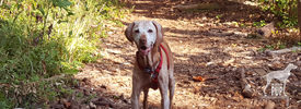
Tavish seemingly not intimidated by the Tail of the Dragon with a motorcycle in its clutch.

Tavish the Intrepid Pup‘s therapy dog vest sports several pins, many of which represent places he’s traveled. Mostly they’re conversation starters, and by far the one that attracts the greatest attention—primarily from kids—is the Day-Glo yellow one shaped like a road sign bearing the silhouette of a dragon and the words, “At the Gap there be dragons.” Here’s the backstory:

Last July, Tavish and Team Tavish were visiting friends in Tennessee who were eager to show us the Tail of the Dragon. It’s a storied stretch of Highway 129 that straddles the border of Tennessee and North Carolina. More accurately, it’s 318 curves in 11 miles with up to a 12% grade and 1800 feet in elevation. Hence the vivid and apt comparison to a jagged dragon’s tail. Were it a TV commercial, it’d have that impossibly fine print flickering across the bottom of the screen saying, “Do not attempt. Professional driver on a closed course.” Indeed, there have been vehicle performance tests done here, and for obvious reasons, the road is a magnet for motorcycle and sports car enthusiasts.

We had visions of “slaying the dragon” Easy Rider-style, with a Doggles®-wearing Intrepid Pup in a cool sidecar. The biggest problem with this plan was that neither we nor our friends own motorcycles. So, we did this trip in decidedly less hip fashion in what was probably an affront to the road itself: our friends’ 2001 Hyundai Elantra. Eat your heart out, James Dean.

Deal's Gap Motorcycle Resort's Tree of Shame

Who says that kinetic, post-modern sculpture can only be found in chic art galleries? Deal’s Gap has a pretty good example with its “Tree of Shame.”

Our friend drove and would periodically concede to the far more intrepid bikers by easing into paved pull-offs, earning us many appreciative nods and an occasional wave. It was also blisteringly hot that day, so the Intrepid Pup was favoring the Elantra’s AC vents over lolling out the window. But even without a white-knuckled Nürburgring experience, this was still a drive we’re glad we did.

There are a handful of entrepreneurial outfits that station photographers along the Tail of the Dragon. The business model is akin to having your photo taken at an amusement park while on some giant roller coaster and then having the opportunity to purchase said photo as you exit the ride. (Editor’s note: We did go online afterwards and easily found ourselves in that day’s batch of pictures…after all, there aren’t exactly zillions of silver Elantras amid the supercars and slick Harley-Davidsons. And, as you might’ve guessed, our souvenir car shot is best left to your imagination.)

Rounding the final curves and easing down that last slope (Wheelie Hill), reward you with the gateway attraction that is Deal’s Gap. Touting its own special brand of self-proclaimed “two-lane tourism,” Deal’s Gap consists of Tail of the Dragon LLC (an outlet store and de facto visitor information center) on one side of the highway and Deal’s Gap Motorcycle Resort (with accommodations, a shop, and a 65-seat pub) on the other.

Deal's Gap statuaryThere are two standouts in this spectacle. One is the signature green “tail” pictured above. The other is the Tree of Shame  located in the motorcycle resort’s parking lot. This crowd-sourced totem is part whimsy, part rite-of-passage, and part cautionary tale. Basically it’s 20+ years of jetsam—smashed reflectors, blown tires, broken headlights, dented hubcaps, and shorn fenders—lobbed in frustration by those unlucky enough to have been “bitten by the dragon.”  The tree is always in flux as pieces get added or otherwise shift among the branches (a nearby sign warns, “CAUTION: Watch for falling parts from Tree of Shame”). It’s also a good reminder that riding the Tail of the Dragon carries an inherent risk; over the past 12 years, there’s been an average of slightly more than two deaths a year.

The parking lot is better than any showroom for gawking at the bikes, and it was here that Tavish made a few new friends. He plunked down in the shade by a random, concrete statue (doorstop?) of a bikini- and bandanna-clad biker and drew his fair share of affectionate pats from bikers returning to their rides. Many intended to traverse the route several times that day, and one biker nostalgically reminisced to us about his own pup that he never wanted to be away from for too long.

Maybe, just maybe, Tavish will get that ride in a sidecar yet!

Dogging the Detaihttp://tailofthedragon.com/index.htmlls

Click to see what a "1" on the Wag-a-meter means

35°27′59.77″N,  83°55′9.99″W
Highway 129
(a.k.a. Tail of the Dragon),  Tennessee/North Carolina, with a stop at Deal’s Gap

35°18′22.87″N,  84°00′46.45″W
Cherohola Skyway (Routes 143/165), North Carolina/Tennessee

This excursion rates a “1” on the Intrepid Pup wag-a-meter. It was a fun, scenic outing and, aside from the driving, was not very strenuous…particularly if you’re a dog! In all, we covered 113 miles that afternoon, but this represented three hours of actual driving time, because speed limits are just 30 mph on the Tail of the Dragon and 40 mph on the Cherohala Skyway.

Cherohala Skyway

The Cherohala Skyway is the “mile-high legend.” Tavish proves it by standing at the Santeetlah Overlook, the route’s highest elevation at 5390 feet.

We had started out just south of Knoxville, snaking southeast on the Tail of the Dragon. En route we passed the Cheoah Dam. Besides holding back the water of the Little Tennessee River, it’s also famous for being the dam from which Dr. Richard Kimble—portrayed by actor Harrison Ford—swans dives in the 1993 thriller The Fugitive. It wasn’t easy for us to pull off the road right then, so there’s no Intrepid Pup photo…you’ll just have to take our word for it. We decided to extend our drive by daisy-chaining from the Tail of the Dragon right onto the Cherohala Skyway, a 60-mile, high-elevation road running west from Robbinsville, North Carolina, to Tellico Plains, Tennessee. But be sure to top off your fuel tank at Deal’s Gap as there are no gas stations on this segment. The route takes its name from the two national forests (Cherokee and Nantahala) it transects.

We made a couple stops along the Skyway to check out some pretty amazing vistas. From the sheer elevation, it’s easy to see why much of the highway gets closed during wintry weather.  Before a passing thunderstorm hit, we were also able to stretch our legs and get in a short 0.75-mile hike with Tavish along a roadside trail with interpretive signs about railroads and timber harvesting.

Save

Journey to the Edge of Shangri-La

Catoctin Trail

That got your attention, didn’t it? OK, so while Tavish the Intrepid Pup technically didn’t stumble upon the mystical paradise described in Lost Horizon, he came pretty close to a Shangri-La. In Thurmont, Maryland, that is.

Catoctin Mountain Park, administered by the National Park Service, is some 10,000 acres of hardwood forest interspersed with recreational areas and a lot of history. Its past is interwoven with that of sawmills, whiskey stills, tanneries, charcoal production, and pig iron. In the 1930s it was shaped into the Catoctin Recreational Demonstration Area by the WPA and the Civilian Conservation Corps. Of this expanse, the Hi-Catoctin Camp for families of federal workers caught the eye of President Franklin D. Roosevelt as a viable spot for a presidential retreat. Roosevelt hadn’t been too keen on adopting his predecessor President Herbert Hoover’s retreat (Camp Rapidan) in Shenandoah, in part because its remoteness presented challenges for Roosevelt’s physical condition. But Hi-Catoctin was just an hour northwest of Washington, DC, and refreshingly cooler in the summer to boot. Roosevelt first visited Catoctin in April 1942, and the existing camp was quickly converted to a presidential retreat he dubbed “Shangri-La” after the utopia in James Hilton’s popular 1933 novel. It became a true haven for the president during World War II, and British Prime Minister Winston Churchill even came there for the Third Washington Conference in 1943. After Roosevelt’s death, President Harry Truman recognized the importance and significance of Shangri-La and preserved it through an arrangement with the National Park Service. When President Dwight D. Eisenhower came into office, he readily embraced Shangri-La but with one significant modification: he renamed it Camp David after his grandson! It’s kept that name ever since and has seen several historic moments, from visits by Leonid Brezhnev, Nikita Khrushchev, and Margaret Thatcher to the 1978 summit with Anwar Sadat and Menachem Begin culminating in the Camp David Accords. As you might suspect, Shangri-La (a.k.a. Camp David) is neither visible from any of the park roads nor open for visitation by the general public even if you do find it.

However, you have the whole rest of the park at your disposal, and with 25 miles of available hiking trails ranging from easy to strenuous, you can readily assemble an itinerary that strikes your fancy. We ended up covering about 5 miles during our visit by hiking the out-and-back Cunningham Falls Nature Trail (2.8 miles round-trip, with a nice view of the falls), the Hog Rock Nature Trail loop (1.5 miles, featuring 14 kinds of trees and nice vista of the Monocacy Valley), and the Blue Ridge Summit Trail (0.6 mile round-trip, with a rocky overlook at an elevation of 1520 ft). Just to manage expectations: at no time did Bo, President’s Obama’s Portuguese Water Dog, come bounding up to us. In fact, we were kind of surprised by how uncrowded the park was, but we chalked it up to the fact that rain in the forecast was keeping folks away. We’ll definitely be back to tackle some of the other routes!

Click to see what 2 on the Wag-A-Meter meansDogging the Details

39°39′1.54″N,  77°27′50.65″W
Catoctin Mountain Park, Thurmont, Maryland

39°37′5.79″N,  77°24′56.46″W
The Cozy’s Camp David Museum, Thurmont, Maryland
[Update: The Cozy closed in June 2014]

This excursion is a solid “2” on the Intrepid Pup’s wag-a-meter. Catoctin is a great natural setting that welcomes leashed dogs, and the hiking trails are very well marked and maintained.

Catoctin Mountain Park

Tavish on the lush and shady Cunningham Falls trail. We passed a total of six other dogs on this popular route.

Make the Park Service’s Visitor Center at Catoctin Mountain Park your first stop. There is no entrance fee for the park, although rates do apply if you’ll be availing yourself of any of the four cabin camp rental sites. The ranger can outfit you with a trail map and recommend what hikes will best suit your group and the time you have available. Particularly neat is the park’s current initiative, the “Healthy Park | Healthy People Challenge.” You’re given a pamphlet listing a combination of 13 interpretive trails and scenic overlooks in the park. With each destination attained, you have a ranger record it on your sheet. Make it to all 13 spots and you’ll earn a special Catoctin Mountain Park carabiner!

The Visitor Center contains restroom facilities, outdoor trash receptacles, a small museum covering the cultural heritage and natural history of the region, and a park bookstore/gift shop that even carries collapsible water bowls and pet bandanas stamped “National Bark Ranger” (um, yeah, we bought one).

After truly enjoying hiking in the park, our next stop was the historic Cozy in downtown Thurmont. Established in 1929, Cozy is Maryland’s oldest restaurant still run by its founding family. That in and of itself makes the Cozy noteworthy in this day and age, but it’s the Cozy’s other claim to fame that had Team Tavish intrigued. In addition to the Cozy Country Inn and Cozy Village Shops, the Cozy complex is home to the nation’s “only museum of Camp David history.” You come upon the outdoor painted plaque that says that Mamie Eisenhower and Babe Ruth are among the notables who’ve dined here, open the door to the family-style restaurant,  and boom:  there’s the Camp David Museum.

Camp David MuseumA modest-sized room off the main dining area serves as the gallery chock full of photographs and memorabilia highlighting the Cozy’s Camp David connections to 13 presidential administrations and counting. There’s a perfect photo opp beneath a rustic “Camp David” sign, but sorry, no dogs allowed inside.

For security reasons Camp David doesn’t show up on the Park Service trail maps, but area residents are accustomed to Camp David hubbub and seem happy enough to demystify things for you. One nice lady we met (alas, didn’t catch a name) recalled how broadcast journalist “Barbara Wawa” would hike up her skirt and vault a fence so she’d be the first out to the helicopters that used the parking lot of a local car dealership as a  landing pad. Time was that President Franklin D. Roosevelt’s Secret Service agents stayed at the Cozy. JFK’s cabinet members often dined there, and the Cozy was the lodging of choice for guests attending President George H. W. Bush’s daughter Doro’s wedding at Camp David in 1992. And then there were tales of television reporters who had their favorite yards or trees downtown that they’d always use as backdrops for reporting “live from Camp David”…even though all the locals watching the evening news knew better.

Yet, despite the G8 Summit being held at Camp David just two months ago (May 2012), Team Tavish detected a hint of wistfulness in our new-found Thurmont-er friend. “It’s not quite like it used to be,” she said. “Now all those world leaders just Skype and email each other, you know. And President Obama really seems to be more of a beach kind of guy, so I don’t think he gets up here as much as some of the other presidents did.”

Everything in the Cozy’s various displays has been donated over the years by visiting White House staffers, dignitaries, and members of a generous press corps. It seems that the bus tours that stop for repast at the Cozy are a pretty discerning bunch, and it apparently hasn’t gone unnoticed that the Obama section of the Camp David Museum is a little sparse. Don’t blame the Cozy, however, as they know their audience and aim to please. They’ve submitted requests for items through “official channels” and have even improvised by adding a few generic images of the First Family. But at the end of the day, Team Tavish had to concur with the assessment of our casual acquaintance: “Photos downloaded from the internet somehow just don’t cut it.”

So, if someone at the White House happens to be reading this (and we know hope you are!), the Intrepid Pup encourages you to  “throw a bone” to the Cozy’s Camp David Museum in the way of some Obama swag and a few recent photos of the president at Camp David. Who knows? It might just translate to some key votes from Thurmont-ers and Cozy-philes in the November elections.

Monticello, Dogs, and the 4th of July

Monticello Thomas Jefferson’s name gets bandied about quite frequently on the fourth of July. Famously linked to this date first for his role in writing the Declaration of Independence, Jefferson also made history by dying on July 4th fifty years later…the exact same day as his Declaration co-author and former political adversary John Adams.

So, on this our country’s 236th birthday, Intrepid Pup shares a recent visit to Thomas Jefferson’s hilltop home of Monticello.

Thomas Jefferson (1743-1826) was a young nation’s first Secretary of State, second Vice President, and third President…a veritable trifecta that meant he was indeed a busy man whose home—despite being started in 1768—took forty years to complete. Today, the distinctive plantation with its Palladian architectural influences is the only U.S. residence that’s also a designated UNESCO World Heritage site.

Moniticello

Tavish overlooks Jefferson’s gardens from the airy pavilion, much as Bergère and her progeny might have done more than 200 years ago.

Historians are always quick to cite Jefferson’s intellect and endless fascinations:  natural history, architecture, gardening, cooking, viticulture, farming, literature, politics. But dogs? This founding father seemed to take a purely utilitarian view—not uncommon in late 18th-century America—of the canine species. Jefferson opined that, in general, the dog population should be highly controlled (and even regulated and taxed) as dogs often proved to be carriers of disease and a scourge upon livestock. A comprehensive article on this topic appears in the “Thomas Jefferson Encyclopedia” section of Monticello’s website.

That all being said, Jefferson also felt that certain birds and animals from the Old World should be introduced to America. Among these was a “shepherd’s dog,” and Jefferson took it upon himself to import three such dogs from France (a female named Bergère and two puppies she whelped during the trans-Atlantic passage) in 1789. There’s been much speculation as to just what kind of herding dogs these were, since Jefferson’s archival records lack this particular detail. The experts’ best guess? Large Briards. Jefferson’s farm animals included sheep, cows, and various poultry, and it seems that Bergère et al were kept as true working dogs. More of the “chien de berger” came to Monticello in 1790 and 1809, with the latter dogs personally selected by the Marquis de Lafayette! As Albemarle County landowners increasingly acquired sheep, Jefferson’s dogs came into high demand, and correspondence indicates that he carefully bred his dogs and supplied the puppies to relatives, friends and neighbors.

Bergère’s happy—but, presumably, purely coincidental—legacy is that Monticello remains a dog-friendly destination. So long as you keep your dog leashed and outdoors, dogs are welcome to explore Monticello’s historic grounds.


Dogging the Details

Click to see what 2 on the Wag-A-Meter means 38°0′35.34″N,  78°27′9.85″W
Monticello, Charlottesville, Virginia

For Monticello’s pet-friendly culture and sheer number of things to see and do, this excursion ranks a “2” on the Intrepid Pup’s wag-a-meter.

Your visit will begin in the parking lot. Don’t miss seeing the African-American graveyard. It’s near the picnic area and entrance to the 2-mile Saunders-Monticello Trail (important note: dogs are permitted only on the section that runs through Kemper Park at the opposite end of the trail). From the parking lot you’ll approach the Visitor Center for your tickets. There’s a theater showing a 20-minute introductory film, an educational center, a cafe, and a well-stocked museum shop (sorry, no dogs in any of the buildings). Though your dog also can’t accompany you into the Robert H. and Clarice Smith Gallery, you’ll want to check this out, too. This compact museum space addresses diverse themes—from slavery to Monticello’s design—and tackles abstract concepts like Jefferson’s words and ideas in a creative way: see for yourself!

Monticello

Dogs can’t take the shuttle (left), but the walking trail (right) begins just across the road from the Visitor Center shuttle stop.

To cover the distance between the Visitor Center and the house with your dog, you won’t be able to ride the courtesy shuttle. Not to worry: there’s a gently sloping, shady 0.6-mile gravel path through the woods that only takes ~20 minutes. Allow more time if you stop to linger en route at Jefferson’s gravesite.

We were pleased to find trash receptacles placed throughout the grounds (though not on the woodland trail), and we were conveniently able to refill water bottles for Tavish from restroom facilities and from the drinking fountain at the Museum Shop adjacent to Jefferson’s extensive vegetable garden.

Monticello beer cellar

Tavish cools off in Monticello’s beer cellar. Jefferson’s wife Martha (1748-1782) oversaw the brewing of 15-gallon batches every two weeks. A British brewer visited Monticello in 1813–due to being detained in the War of 1812!–and, based on his input, the estate switched to producing biannual 100-gallon runs of ale.

Since dogs aren’t allowed inside the main house, Team Tavish took the timed-entry guided tour in consecutive one-hour shifts. This meant that Tavish had a full two hours to explore Jefferson’s estate, and there really was plenty to hold his (and our) interest. We’d been informed that Tavish could accompany us on any of the seasonally-offered “gardens and grounds” tours included in the general admission fee. While we saw many of these in progress, we opted to explore on our own and even encountered a few other visiting dogs. The beautiful flower beds on the west lawn were in full bloom, and from the north terrace we could just make out in the distance the Jefferson-designed rotunda at the University of Virginia. We surveyed the orchards from the vantage point of the garden pavilion. And when we needed some shade, we took a self-guided tour through the cool cellar passage that runs the full width of the main house and terraces and gives you a peek at Monticello’s dependencies .

Plan on spending a minimum of 3 hours at Monticello to savor the history and the views!


Save

Outdoors and on the Water

Pohick BayAre you indoors reading this?  If so, take it outside!

Today, June 9th, is officially National Get Outdoors Day (GO!). If you regularly follow Tavish the Intrepid Pup, you already know his affinity for being out and about, and he needs no further invitation to get outside. But the goals of “GO!” are to encourage first-time visitors to public lands and to reconnect youth to nature. “GO!” is one of a growing number of public initiatives in recent years to embrace such themes. Richard Louv’s best-selling book, Last Child in the Woods, sounded the alarm in 2008 about “nature-deficit” and the corollaries with childhood obesity, attention disorders, and more. As we’ve become more plugged in to what’s on a screen than what’s in our backyard, entities as disparate as the U.S. Forest Service (More Kids in the Woods), the NFL (Play60), the National Wildlife Federation (Be Out There), and First Lady Michelle Obama (Let’s Move!) have launched national campaigns to help reverse this trend.

There’s no doubt that Tavish’s own need for exercise and activity has helped members of Team Tavish maintain healthier lifestyles. And while Tavish’s exploits have gotten him outdoors in more than a dozen different states, it’s important to point out that connecting to nature needn’t be complicated nor involve expensive travel plans to far-flung locales. So in that spirit, we’re highlighting below a simple, low-cost excursion that took us to a regional park for an all-new outdoor experience for Tavish. In other words, if you can’t replicate this exact itinerary, we’re pretty sure you can do something similar in most parts of the country. So, hurry outside and enjoy!

Dogging the Details

38°40′25.27″ N, 77°9′55.13″ W
Pohick Bay Regional Park, Lorton, Virginia

Click to see what 2 on the Wag-A-Meter meansTavish has been on several boats (car ferries, tour boats, etc.) over the years, but he’d never been on anything of the “personal watercraft” variety… until his visit to Pohick Bay Regional Park. The park is one of 24 administered by the Northern Virginia Regional Park Authority. Its other claim to fame is that it’s the terminus of the Occoquan Water Trail, an extraordinary 40-mile route along two tributary waterways of the Chesapeake Bay.

In addition to having woodland hiking paths, a marina, and expansive picnic areas, Pohick Bay Regional Park seasonally offers boat rentals for really reasonable hourly and day rates. If you don’t own a boat, it’s a great way to test out paddle boards, pedal boats, canoes, kayaks, sailboats and jon boats. Better yet, at this particular park you can bring your dog along on the rental! Intrepid Pup has an affinity for the water—ocean, stream, pond, you name it!—but he’s ultimately more of an enthusiastic splasher/wader than an active swimmer. At 45 lbs, a freaked out Tavish scrambling around on a canoe or sit-upon kayak offshore could be problematic. So since we didn’t quite know how he’d react to being out on the water, we opted for the stability of a jon boat. It’s essentially a sturdy, flat-bottomed metal rowboat with a low center of gravity (read: clunky tub really hard to capsize). Turns out we needn’t have worried as Tavish was more than happy to situate himself as close to the edge as possible to take in the scenery while one of us rowed (see photo above).

Clearly this was one outing where we expended way more energy than the Intrepid Pup did, but we got a good workout, saw several osprey and herons, and—perhaps most importantly—happily confirmed that boating with Tavish was something we could do again. We’d dearly love to get the Intrepid Pup out in a kayak, and the top choice (although it’s not among the rentals at Pohick Bay) to try would be Perception Kayaks’ new recreational model, the Prodigy 13.5. Its over-sized cockpit and a second removable half-seat are specifically designed with a “small companion” (be it a child or a dog) in mind. Brilliant!

The combination of a low boat rental rate and a high degree of fun earns this excursion a “2” on the Intrepid Pup’s Wag-a-Meter. Key things bring along for yourself include a snack, water, sunscreen, sunglasses, and a hat. For your dog, keep plenty of water aboard. Tavish’s short coat makes him especially susceptible to sunburn and/or overheating, so we had lots of water available for him to drink out of his collapsible travel bowl, and we made sure we didn’t stay out too long in the heat of day. One final note: Tavish wears a life vest when he’s on the water. Intrepid or no, it’s a wise move and potential life saver for humans and dogs alike.

Turtles, Goslings & Lily Pads, Oh My!

Tavish at Kenilworth Aquatic Gardens

Tavish at the lily ponds. The hardy and tropical water lilies were blooming, little jewels of color amid the emerald green pads. Surrounding many of the ponds are irises, but the yellow variety is invasive. It is still too early for the lotus blossoms that are hallmarks of the summer months.

Even if today wasn’t National Public Gardens Day, we’d be touting Kenilworth Park & Aquatic Gardens. Did you know that it’s the only National Park Service site devoted to the cultivation and care of aquatic plants?

The precise story behind Kenilworth is one you couldn’t make up if you tried. Walter B. Shaw was a Civil War veteran who had lost his right arm in the fighting. He settled in Washington, D.C., securing a job as a Treasury Department clerk after teaching himself to write left-handed. Outside of government work, however, Shaw’s true love was water lilies. Eager to propagate them, he secured a dozen specimens from his home state of Maine and placed them in an unused ice pond on his 30 acres. When his hobby outgrew the one pond, he simply built more ponds until—under the auspices of the newly established W. B. Shaw Lily Ponds—he was successfully collecting exotic varieties, experimenting with hybrids, and commercially shipping plants nationwide. His daughter Helen Shaw Fowler joined him in his business ventures, and together they opened the gardens for the public’s enjoyment. Under Helen’s careful stewardship, the gardens expanded even further after Shaw’s death in 1921, and literally thousands of visitors a day (including President and Mrs. Coolidge!) flocked to marvel at the aquatic blooms during the summer months.

Fast forward to the 1930s and the U.S. Army Corps of Engineers was faced with dredging the silt-choked Anacostia River, an act that would have signaled the demise of the gardens. Helen fought the plans and an accord was reached in 1938 when Congress allocated $15,000 to purchase eight acres of the gardens for public preservation. Helen continued to live on the property until her death in 1953 but taught Fred Lundy, a gardener with the National Park Service, how to care for the water lilies. The Park Service eventually took over management of the garden and renamed it Kenilworth to reflect the name of the broader community. Today the park consists of 45 ponds of water lilies across 12 acres, enveloped by another 70 acres of freshwater tidal marshlands.

Midday yesterday Tavish the Intrepid Pup was eager to start exploring, and everything about his body language screamed, “What magical place is this, anyway?” Talk about sensory overload! At the lily ponds there were Canada geese (and therefore also a lot of goose droppings). We’d been advised by the park ranger when we arrived that there were several fledglings about, so we kept our distance. Tavish was actually pretty unphased by these tawny goslings paddling by…because there were BUTTERFLIES! And FROGS!  Ok, so technically we never saw a frog, but from the blurs of color and the loud splooshing sounds, we could tell they were big. It was great fun watching Tavish try to anticipate where the next blur and sploosh would come from. Oh, and the TURTLES! There were a few small painted turtles perched on logs, but they had nothing on the dinner platter-sized snapping turtles hanging out sunbathing at the ponds’ edges. These guys were perceptive and before we could come within ten paces it was like those targets in a county fair shooting gallery where each  toppled in succession with an unceremonious plunk. Invariably we were rewarded with a closer look when a few poked their heads back up out of the muddy water.

Tavish at Kenilworth Aquatic Gardens

Though hard to disengage Tavish from the endless fascinations of the lily ponds, we did finally make it onto the River Trail (note: NOT a loop; it’s 0.7 miles each way). It meanders in a northwesterly direction among the thick scent of honeysuckle and then follows the bend of the Anacostia River for a stretch. It ends at the inlet into the marsh itself, which is where you’d enter Kenilworth if coming by kayak or canoe. You never fully escape the incessant thrum of car traffic careening by on Route 50, punctuated by the occasional clatter of an Amtrak train crossing the railroad bridge. Where this might be overtly annoying in another setting, in a strange way, the noise serves notice that this fragile environment struggles to exist in spite of urban encroachment.

Returning to the lily ponds, we set out in the opposite direction onto the extensive boardwalk. Signs along the trail have faded considerably, but on this sunny, breezy afternoon we didn’t exactly need a plaque to tell us that the fish and tadpoles were plentiful. Tavish kept poking his head through the railing to watch them. Red-winged blackbirds darted among the tall grasses, and a great blue heron soared above. Just another spectacular day in the marsh.

Dogging the Details

38°54′45.50″N,  76°56′31.24″W
Kenilworth Park & Aquatic Gardens
, Washington, DC

Tavish at Kenilworth Aquatic Gardens

Click to see what 2 on the Wag-A-Meter means

It can be a little tricky navigating this residential area in northeast Washington to find the proper entrance to the aquatic gardens, so if you have GPS, use it!

Intrepid Pup has been to Kenilworth before, but it really pays to be a repeat visitor. While the walking trails are always nice, the visual appeal of the ponds changes dramatically throughout the seasons.

When we stopped in at the visitor center to snag a map, the Park Service ranger—a helpful young woman who, come to find out, was getting married this weekend at another National Park—was genuinely pleased to see us and remarked, “Kenilworth definitely welcomes leashed dogs!” The dog-friendly trails and scenery earn Kenilworth a “2” on the Intrepid Pup wag-a-meter. Of course, the general courtesy about cleaning up after your dog still very much applies, and there are waste receptacles conveniently located throughout the front section of the gardens (though not so much on the River Trail or boardwalk sections).  Tavish stayed in the vestibule of the Visitor Center as dogs aren’t permitted inside, but there is a small bookshop and a series of compact displays about the importance of the wetlands and the history of Kenilworth—from use as the fishing grounds of the Nacotchtank peoples through to the present day.

Walk every step of the grounds around the various ponds, out-and-back on the River Trail, and along the boardwalk, and you’ll be lucky to have eked out 2 miles. But you’ll easily have whiled away an hour or two, especially if you have a curious pup intently stalking every lily pad fluttering in the breeze!