Oh Shenandoah, I Long to See You

Brown House at Rapidan Camp

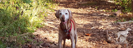
In visiting Rapidan Camp, Herbert Hoover’s presidential retreat in Shenandoah, the Intrepid Pup follows in the footsteps of such luminaries as aviator Charles Lindbergh and inventor Thomas Edison. Here, Tavish lounges on the porch of Brown House, the Hoovers’ personal cabin, at the terminus of the 2-mile Mill Prong Trail.

Rapidan's Outdoor Hearth

Rapidan Camp’s outdoor fireplace provides a good backdrop for photos, just as it did in Hoover’s time.

From 1929 to 1932, President Herbert Hoover and First Lady Lou Henry Hoover relished their rustic fishing camp in Shenandoah. Fortunately, three of the 13 original buildings constituting their Rapidan Camp have been preserved, and you can enjoy it, too.

One option is to board a shuttle bus at the Byrd Visitor Center for a ride down a fire road as part of a three-hour, ranger-led tour. But you can’t bring your dog. And that hardly seems sporting when the second option is a moderate hike that’s dog-friendly. The trail to Rapidan winds through the very forests that so appealed to the Hoovers as a presidential retreat just 100 miles from the pressures and summer humidity of Washington, DC. The Hoovers built the camp with their own funds, the design largely influenced by the First Lady’s own experience in working with the Girl Scouts. Their personal cabin, known simply as The Brown House, had a comfortably open floor plan, welcoming hearth, and Navajo rugs. The president maintained a separate bedroom/office so he’d not disturb his sleeping wife when White House business kept him burning the midnight oil. Meals were eaten in a communal mess hall to promote camaraderie. Days were spent fishing, horseback riding, and entertaining a steady stream of official guests.

The Hoovers' Norwegian Elkhound Weejie

The Hoovers had several dogs, but it’s their Norwegian Elkhound named Weejie who most often appears in Rapidan Camp press photos like this one from 1932. This particular AP image is part of the onsite interpretive exhibit at Rapidan’s Prime Minister’s Cabin.

Hiking into Rapidan affords you the opportunity of getting the lay of the land. Outdoor signage marks where the other buildings used to stand, and the Prime Minister’s Cabin (so dubbed for Ramsay MacDonald’s visit in 1929) now contains a comprehensive exhibit about the Hoovers and how their presence shaped development in the region. In addition, a park volunteer is on hand most of the year to answer questions and provide hikers with impromptu tours of the Brown House. Our arrival was met by a very personable and knowledgeable history Ph.D. graduate student named Jonathan who was living onsite in the Creel House and serving as Rapidan’s resident caretaker for the summer. From him we learned that Hoover gifted Rapidan Camp to the government upon leaving office, and the camp was incorporated into Shenandoah National Park in 1935. The camp enjoyed use by the Boy Scouts up until 1959, when the Park Service removed all but the existing three structures. Rapidan continued to host senior U.S. officials into the early 1990s, although Maryland’s Camp David had long since supplanted Rapidan as the official presidential retreat.

The grounds and buildings underwent a full restoration in 2004 to return them to how they appeared during the Hoovers’ residence, and they remain a fascinating time capsule of a bygone era.

Dogging the Details

Click to see what 2 on the Wag-A-Meter means38°29′26.49″N, 78°25′10.93″W
Rapidan Camp, Shenandoah National Park, VA (trailhead at Milam Gap)

The Intrepid Pup wag-a-meter registers an emphatic “2” for this excursion. It requires a modicum of  pre-planning, but the pay-offs include a good workout and a unique historical destination.

With more than 500 miles of hiking trails and only 10 trails on which pets are not permitted, there’s a lot for you and your leashed dog to explore at Shenandoah National Park. If you’re coming by car, there’s a $15 entrance fee per non-commercial vehicle (slightly less if it’s December – February), and your pass is good for the day of entry and the next 6 days, so you’re definitely getting your money’s worth. Road and trail maps are available at any of the ranger stations, and you can download a map for the Rapidan Camp area here.

Mill Prong Trail

Tavish at one of three stream crossings en route to Rapidan Camp

Begin your journey by parking at the Milam Gap pull-off just shy of mile marker 53 along Skyline Drive. The Mill Prong Trail is the most direct route to Rapidan Camp, and the trailhead is just across the street from the parking area. The path is shady, well-groomed and well-marked with tree blazes and concrete posts at trail junctions. It’s two miles downhill on the way in. There are three water crossings, but unless the streams are running high, you can easily ford them by stepping from boulder to boulder. With the last water crossing at Big Rock Falls—a distinctive but gentle cataract flowing into a shallow pool—you’re on final approach to Rapidan Camp.

Nature-wise there were butterflies, huge millipedes, and a couple of chipmunks. Ultimately we encountered more gnats (note: insect repellent is helpful) than hikers and saw no other dogs…but we suspected that it gets more crowded on the weekends. Hiking in took an hour but included several photo stops. For the return trip, we hiked out the same way we came (for a 4-mile round trip total). But if you’re up for a longer circuit hike (7.4 miles total), the alternative is to pick up the Laurel Prong Trail at Rapidan Camp and follow it until it intersects with the Appalachian Trail, which turns northward over Hazeltop Mountain and ends back at the Milam Gap parking area.

Pet-friendly lodging:

Team Tavish enjoys camping, but for this particular trip we had sought a night’s stay in pet-friendly accommodations and were pleased to find a few choices. There are a limited number of in-park, pet-friendly rooms at Lewis Mountain Cabins, Skyland, and Big Meadows Lodge.  We opted for a traditional room at Big Meadows, as it was closest to the trailhead for Rapidan Camp. It was reasonably priced and offered adequate amenities: coffee maker,  double beds, and a small bathroom (no phones or TVs, but there is wi-fi and a TV room in the main building, if you’re so inclined). While dogs aren’t allowed inside the main lodge where the dining options are, you can get pub fare from the Taproom restaurant and eat on the terrace with its none-too-shabby view of the sunset over the Blue Ridge. We saw probably a half dozen dogs being walked on the grounds the next morning, so clearly we weren’t the only ones availing ourselves of the pet-friendly lodging.

Tavish sees a snake

From a safe distance, Tavish observes what was by all accounts Rapidan Camp’s resident non-venomous snake.  We’d read that snakes can strike at a distance up to half their body length. Had this been one of Shenandoah National Park’s pit vipers—identifiable in part by their more triangular-shaped heads—Intrepid Pup wouldn’t be posing for a photo.

Special considerations:

Mosquitoes and ticks are almost givens in any woodland excursion, but hiking in Shenandoah presents two additional cautions (yay!): snakes and bears. Poisonous copperheads and rattlesnakes do reside in the park. Read up on dog-versus-snake encounters, and you’ll be sufficiently freaked out. Dogs usually weigh less than people and thus are more readily “incapacitated” (to use a euphemism) by snake venom. That being said, the snakes in Shenandoah aren’t exactly out trolling for hikers and dogs and would much rather be left alone. In the end, Team Tavish concluded that basic avoidance was going to carry the day, and our modus operandi was hyper-vigilance about not letting Tavish stray from the main trail so he could literally let sleeping snakes lie.

Shenandoah National Park also has one of the densest populations of American black bears in the United States, and pretty much any piece of park literature you’re apt to find includes information about bear safety. They’re purportedly “skittish” and tend not to pose any threat so long as you give them a wide berth, keep food out of the equation, and don’t run away. Another oft-repeated piece of advice is to “let the bear know you’re human” (i.e. wave your arms, make noise, speak in normal tones, etc.), but our travel companion—a close family friend and fellow blogger—joked that in the event of a bear encounter she would also be readily enumerating her other human attributes like, “I can read, I have opposable thumbs, and I have relatives that care about me.” As it turns out, we were glad to have reviewed bear basics because while hiking the 4-mile Rose River Loop Trail the next day, some oncoming hikers alerted us that they had just seen a bear not 200 yards ahead. They said it had shuffled off into the woods when it heard them approaching and, indeed, we never saw it.  We did, however, catch a glimpse of a bear standing at the side of the road as we were driving out of the park.

Special gear:

While you can count on temperatures being cooler in the mountains, you still need to keep hydrated, so bring plenty of water for yourself and your dog. Team Tavish used a CamelBak for water and snacks, and Tavish carried his own water and gear in Ruffwear’s Palisades Pack™ (be on the lookout for an upcoming product review in the near future). Remember to keep your dog on a 6-foot leash as the park’s leash policy is enforced for the safety of dogs, visitors, and wildlife alike. Finally, beautiful scenery is at every turn, so don’t forget to pack a camera!

Journey to the Edge of Shangri-La

Catoctin Trail

That got your attention, didn’t it? OK, so while Tavish the Intrepid Pup technically didn’t stumble upon the mystical paradise described in Lost Horizon, he came pretty close to a Shangri-La. In Thurmont, Maryland, that is.

Catoctin Mountain Park, administered by the National Park Service, is some 10,000 acres of hardwood forest interspersed with recreational areas and a lot of history. Its past is interwoven with that of sawmills, whiskey stills, tanneries, charcoal production, and pig iron. In the 1930s it was shaped into the Catoctin Recreational Demonstration Area by the WPA and the Civilian Conservation Corps. Of this expanse, the Hi-Catoctin Camp for families of federal workers caught the eye of President Franklin D. Roosevelt as a viable spot for a presidential retreat. Roosevelt hadn’t been too keen on adopting his predecessor President Herbert Hoover’s retreat (Camp Rapidan) in Shenandoah, in part because its remoteness presented challenges for Roosevelt’s physical condition. But Hi-Catoctin was just an hour northwest of Washington, DC, and refreshingly cooler in the summer to boot. Roosevelt first visited Catoctin in April 1942, and the existing camp was quickly converted to a presidential retreat he dubbed “Shangri-La” after the utopia in James Hilton’s popular 1933 novel. It became a true haven for the president during World War II, and British Prime Minister Winston Churchill even came there for the Third Washington Conference in 1943. After Roosevelt’s death, President Harry Truman recognized the importance and significance of Shangri-La and preserved it through an arrangement with the National Park Service. When President Dwight D. Eisenhower came into office, he readily embraced Shangri-La but with one significant modification: he renamed it Camp David after his grandson! It’s kept that name ever since and has seen several historic moments, from visits by Leonid Brezhnev, Nikita Khrushchev, and Margaret Thatcher to the 1978 summit with Anwar Sadat and Menachem Begin culminating in the Camp David Accords. As you might suspect, Shangri-La (a.k.a. Camp David) is neither visible from any of the park roads nor open for visitation by the general public even if you do find it.

However, you have the whole rest of the park at your disposal, and with 25 miles of available hiking trails ranging from easy to strenuous, you can readily assemble an itinerary that strikes your fancy. We ended up covering about 5 miles during our visit by hiking the out-and-back Cunningham Falls Nature Trail (2.8 miles round-trip, with a nice view of the falls), the Hog Rock Nature Trail loop (1.5 miles, featuring 14 kinds of trees and nice vista of the Monocacy Valley), and the Blue Ridge Summit Trail (0.6 mile round-trip, with a rocky overlook at an elevation of 1520 ft). Just to manage expectations: at no time did Bo, President’s Obama’s Portuguese Water Dog, come bounding up to us. In fact, we were kind of surprised by how uncrowded the park was, but we chalked it up to the fact that rain in the forecast was keeping folks away. We’ll definitely be back to tackle some of the other routes!

Click to see what 2 on the Wag-A-Meter meansDogging the Details

39°39′1.54″N,  77°27′50.65″W
Catoctin Mountain Park, Thurmont, Maryland

39°37′5.79″N,  77°24′56.46″W
The Cozy’s Camp David Museum, Thurmont, Maryland
[Update: The Cozy closed in June 2014]

This excursion is a solid “2” on the Intrepid Pup’s wag-a-meter. Catoctin is a great natural setting that welcomes leashed dogs, and the hiking trails are very well marked and maintained.

Catoctin Mountain Park

Tavish on the lush and shady Cunningham Falls trail. We passed a total of six other dogs on this popular route.

Make the Park Service’s Visitor Center at Catoctin Mountain Park your first stop. There is no entrance fee for the park, although rates do apply if you’ll be availing yourself of any of the four cabin camp rental sites. The ranger can outfit you with a trail map and recommend what hikes will best suit your group and the time you have available. Particularly neat is the park’s current initiative, the “Healthy Park | Healthy People Challenge.” You’re given a pamphlet listing a combination of 13 interpretive trails and scenic overlooks in the park. With each destination attained, you have a ranger record it on your sheet. Make it to all 13 spots and you’ll earn a special Catoctin Mountain Park carabiner!

The Visitor Center contains restroom facilities, outdoor trash receptacles, a small museum covering the cultural heritage and natural history of the region, and a park bookstore/gift shop that even carries collapsible water bowls and pet bandanas stamped “National Bark Ranger” (um, yeah, we bought one).

After truly enjoying hiking in the park, our next stop was the historic Cozy in downtown Thurmont. Established in 1929, Cozy is Maryland’s oldest restaurant still run by its founding family. That in and of itself makes the Cozy noteworthy in this day and age, but it’s the Cozy’s other claim to fame that had Team Tavish intrigued. In addition to the Cozy Country Inn and Cozy Village Shops, the Cozy complex is home to the nation’s “only museum of Camp David history.” You come upon the outdoor painted plaque that says that Mamie Eisenhower and Babe Ruth are among the notables who’ve dined here, open the door to the family-style restaurant,  and boom:  there’s the Camp David Museum.

Camp David MuseumA modest-sized room off the main dining area serves as the gallery chock full of photographs and memorabilia highlighting the Cozy’s Camp David connections to 13 presidential administrations and counting. There’s a perfect photo opp beneath a rustic “Camp David” sign, but sorry, no dogs allowed inside.

For security reasons Camp David doesn’t show up on the Park Service trail maps, but area residents are accustomed to Camp David hubbub and seem happy enough to demystify things for you. One nice lady we met (alas, didn’t catch a name) recalled how broadcast journalist “Barbara Wawa” would hike up her skirt and vault a fence so she’d be the first out to the helicopters that used the parking lot of a local car dealership as a  landing pad. Time was that President Franklin D. Roosevelt’s Secret Service agents stayed at the Cozy. JFK’s cabinet members often dined there, and the Cozy was the lodging of choice for guests attending President George H. W. Bush’s daughter Doro’s wedding at Camp David in 1992. And then there were tales of television reporters who had their favorite yards or trees downtown that they’d always use as backdrops for reporting “live from Camp David”…even though all the locals watching the evening news knew better.

Yet, despite the G8 Summit being held at Camp David just two months ago (May 2012), Team Tavish detected a hint of wistfulness in our new-found Thurmont-er friend. “It’s not quite like it used to be,” she said. “Now all those world leaders just Skype and email each other, you know. And President Obama really seems to be more of a beach kind of guy, so I don’t think he gets up here as much as some of the other presidents did.”

Everything in the Cozy’s various displays has been donated over the years by visiting White House staffers, dignitaries, and members of a generous press corps. It seems that the bus tours that stop for repast at the Cozy are a pretty discerning bunch, and it apparently hasn’t gone unnoticed that the Obama section of the Camp David Museum is a little sparse. Don’t blame the Cozy, however, as they know their audience and aim to please. They’ve submitted requests for items through “official channels” and have even improvised by adding a few generic images of the First Family. But at the end of the day, Team Tavish had to concur with the assessment of our casual acquaintance: “Photos downloaded from the internet somehow just don’t cut it.”

So, if someone at the White House happens to be reading this (and we know hope you are!), the Intrepid Pup encourages you to  “throw a bone” to the Cozy’s Camp David Museum in the way of some Obama swag and a few recent photos of the president at Camp David. Who knows? It might just translate to some key votes from Thurmont-ers and Cozy-philes in the November elections.

O Say Can You Sailabrate?

Sailabration 2012

Tavish gazes at Baltimore’s Sailabration festivities and the visiting ARM Cuauhtémoc, a Mexican Navy tall ship whose home port is Acapulco.

From June 16 through June 19, 2012, Baltimore put the “charm” in Charm City by rolling out the welcome mat, inviting more than 40 tall ships and navy vessels, and dialing in some stellar low-humidity “Chamber of Commerce” weather…all in the name of a Star-Spangled Sailabration commemorating the bicentennial of the War of 1812.

Not one to miss an historic event, Tavish the Intrepid Pup joined the throngs last Saturday. With activities happening citywide at five separate locations, this had the makings of being a logistical and traffic nightmare, so we were pleasantly surprised at how easy it actually was to get downtown. We decided to forgo parking at M&T Bank Stadium when we saw people lined up to park and catch shuttle buses to the various venues and opted instead to park a little further north in Redwood Garage on South Eutaw Street for a reasonable $16 daily rate.  Turns out that this parking garage is a neighbor of the historic Bromo Seltzer Tower and the Baltimore City Fire Department. A few of the firemen standing in the open bay for Engine 23 offered up dog biscuits and a head pat to Tavish as we walked back by. What a nice welcome! It was just a few more blocks down to the heart of the Inner Harbor area. To take it all in, we headed all the way over to the south side and up the embankment of Federal Hill. It offers a  pretty spectacular panoramic overlook of the Inner Harbor, even when there aren’t performance stages, food pavilions, an Adventure Zone, and all those visiting ships!

There were Class B tall ships hailing from ports throughout the country, Class A tall ships (square-rigged, over 40 meters) from as far away as Indonesia and Brazil, and research vessels and gray hulls representing Canada, Denmark, Japan, Mexico, Norway, the UK and the USA. Bedecked with signal flags, they were a colorful sight to behold. All the ships were open for free public tours, but Intrepid Pup was content to skip the lines and take in the views dockside.  We even caught a few glimpses of the U.S. Navy’s Blue Angels doing their precision flyover formations as part of the afternoon airshow.

Just because Sailabration has now concluded doesn’t mean that the official celebration has. Four historic ships are permanently berthed in the Inner Harbor and open for tours:  USCGC Taney (the last surviving warship of Pearl Harbor), the submarine USS Torsk, the Lightship Chesapeake and the sloop USS Constellation. And what’s more, with the War of 1812 so firmly embedded in Baltimore’s cultural identity, its related must-see attractions (Fort McHenry and the Star-Spangled Banner Flag House) are open year round.

Star-Spangled Banner Flag House

Tavish stands watch outside the historic Star-Spangled Banner Flag House.

With its proximity two blocks east of the Inner Harbor, we viewed a walk over to visit the Star-Spangled Banner Flag House as a good chance to temporarily escape the growing congestion on the piers.

The red brick Star-Spangled Banner Flag House dates to 1793 and is a registered National Historic Landmark for good reason:  it was here in 1813 that flagmaker Mary Young Pickersgill and eight other women took six weeks to fulfill a purchase order from Fort McHenry’s commanding officer Major George Armistead for an enormous 30′ x 42′ garrison flag. It was this same flag—still flying after British bombardment of the fort on September 13-14, 1814—that inspired attorney Francis Scott Key to pen the poem that would become the U.S. national anthem. What’s striking about the building is its size. Though relatively roomy by 19th-century standards, you have to keep in mind that this was not only Pickersgill’s house but also her office and “factory.” Most of the flags she sewed or painted for vessels in the Port of Baltimore were far smaller in scale. The soon-famous “star-spangled banner” was fashioned from approximately 400 yards of (ironically) British wool bunting. Each of the 15 stars measured two feet tip to tip, and each of the 15 stripes was two feet wide. In short, this meant that the nearly 100-pound flag was far too cumbersome to piece together in her house, so Pickersgill secured permission to finish it on the malthouse floor of Brown’s Brewery a block away! Amazingly enough, the signed receipt for the flag is retained in the museum’s archival collections. The total bill came to $405.90 for the labor and materials to create the star-spangled banner and a slightly smaller storm flag for the fort to use in inclement weather.


Dogging the Details

Click to see what 2 on the Wag-A-Meter means
39°16′49.01″N, 76°36′31.27″W
Inner Harbor, Baltimore, Maryland

39°17′14.89″N, 76°36′12.57″W
Star-Spangled Banner Flag House, Baltimore, Maryland


Dog-shaped nutcracker

Check out this dog-shaped nutcracker! Intrepid Pup approves. It’s one of many typical 19th-century household implements displayed in the Star-Spangled Banner Flag House. Look for it on the mantel above the hearth in the kitchen when you visit!

As always, we had plenty of water on hand. And, ever mindful of the heat of the midday sun, we made frequent stops for our shade-mongering Intrepid Pup. Fortunately, Baltimore’s Inner Harbor is pedestrian-friendly and well equipped with watering holes, benches, and scenic views for the two- and four-legged alike.

As one might guess, the historic Star-Spangled Banner Flag House isn’t pet friendly, but the exceptionally helpful visitor services staff did allow our Intrepid Pup a brief respite in the adjoining modern, air-conditioned visitors center where we watched a 10-minute introductory film. In fact, all this hospitality is what earned our Sailabration excursion an enthusiastic “2” on the Intrepid Pup wag-a-meter! While half of Team Tavish then went on the approximately 30-minute tour of the house (you can choose between docent-led or self-guided via cell phone), the other half of Team Tavish stayed outside with Tavish.

Tavish at the Star-Spangled Banner Flag House

Outside the Flag House, there’s a spacious courtyard. Tavish is sitting on a clever outline map of the U.S. where each “state” is made of the official state stone (i.e. Petoskey stone for Michigan, granite for New Hampshire, etc.). The flag in the background is the same size as Mary Pickersgill’s 1813 star-spangled original. What Tavish didn’t get to experience was the house tour and the museum gallery and kids’ discovery center on the first floor of the visitors center…but he did see the film!


Lest We Forget

Arlington National Cemetery: Tomb of the Unknowns

From a distance, Tavish witnesses the ceremony underway at the Tomb of the Unknowns. Sentinels from the Third U.S. Infantry headquartered at Fort Myer maintain a round-the-clock vigil. Guard changes occur every hour (and every 1/2 hour from April 1 through September 30) with a somber ritual.

UPDATE: As of October 26, 2016, Arlington National Cemetery no longer permits leashed dogs, except for service animals and military working dogs.

The last place you’d expect to find serenity is among vacationing families, high school field trippers, and trams loaded with tourists. And you’d be right…except this is Arlington National Cemetery. Even without the discreet signage to “conduct yourself with propriety,” most folks inherently realize that this is a place of honor. As such, you might pick up on the fact that there’s no recreational jogging or cycling on the grounds, and a general hush prevails. It’s a place that is at once peaceful but solemn, heroic yet tragic, both beautiful and brittle.

You don’t see many dogs at Arlington National Cemetery, though they are expressly permitted (see “Dogging the Details” below). Not to anthropomorphize, but Tavish our Intrepid Pup clearly picks up on the vibe during our visits that these are times for calm and respect. Usually most content only when his leash is fully extended, here—and without command—Tavish invariably sticks at a close heel.

We initially avoid the bulk of the crowds by walking up the steeply sloping Custis Walk. It winds by the grave of President William H. Taft as well as past the tomb of Mary Randolph, the first person known to be buried at Arlington. At the top of the hill are two memorable sights: Arlington House and a stunning panoramic view across the Potomac River of Washington, DC’s downtown monuments.

Arlington House: The Robert E. Lee Memorial

Maintained by the National Park Service, Arlington House is in the final phase of a multi-year restoration. The building is currently unfurnished, with certain rooms closed to the public, but visitors are encouraged to take a self-guided tour.

Quite simply, were it not for Arlington House, there would be no Arlington National Cemetery. The Greek temple-style house was constructed in 1802 by George Washington Parke Custis (1781-1857), who had been raised from infancy at Mount Vernon by none other than his grandmother Martha (Custis) Washington and her second husband George Washington. Custis intended for Arlington House to be both a family home and a tribute to his illustrious step-grandfather. Further cementing its place in history was the 1831 wedding in the parlor of Custis’s daughter Mary Anna Randolph Custis and Lt. Robert E. Lee, son of Revolutionary War Hero Henry “Light-Horse Harry” Lee. The marriage united two prominent Virginia families. When Virginia seceded from the Union on April 19, 1861, Robert E. Lee resigned his commission from the U.S. Army the next day and sided with his home state. Lee’s decision not only inexorably altered the course of the American Civil War but also cost him his home. To defend the nation’s capital, Union troops made preparations to occupy the strategically situated Arlington House. The Lee family left in haste in May 1861, and when Lee’s wife failed to pay property taxes in person, the home was confiscated. Government officials—interpreting Lee’s loyalty to Virginia as an act of treason—further sought to ensure against the Lees’ return by establishing a military cemetery on their land.  Lee’s uprooted family would never again live at Arlington House, and Arlington National Cemetery was born.

Tavish at Arlington National Cemetery

Tavish on the Custis Walk at Arlington National Cemetery, overlooking the eternal flame at President John F. Kennedy’s grave.

Roads through the cemetery are named almost entirely for American military heroes (Pershing, Nimitz, MacArthur, Eisenhower, etc.). Following them takes you on an introspective journey among the cemetery’s more than 250,000 graves. If you’re of a certain age, the memorials for the crews of Space Shuttles Challenger and Columbia will hold special meaning. And if you’re of another certain age, the eternal flame marking the grave of President John F. Kennedy will take you back to that fateful day in Dallas. Then there’s the main mast of the U.S.S. Maine, erected in the memory of those who died in the explosion in Havana Harbor in 1898. Individual headstones honor the final resting places of veterans who also distinguished themselves in other arenas—folks like heavyweight boxing champion Joe Louis, Supreme Court Chief Justice William Rehnquist,  polar explorer Richard Byrd, and astronaut Gus Grissom. The iconic Memorial Amphitheater provides the backdrop for the Tomb of the Unknowns, and the changing of the guard ceremony will leave a lump in your throat no matter how many times you see it. Further afield is the Pentagon Group Burial Marker, a five-sided black granite memorial to those who died in the Pentagon or on American Airlines Flight 77 during the terrorist attacks of September 11, 2001.

It was here, on our most recent visit (this very Memorial Day weekend), that we were joined by a small group who had just pulled up on their Harley-Davidsons. One middle-aged women initiated conversation, explaining that she was in town for the Memorial Day Rolling Thunder activities that heighten awareness for POW/MIAs. “Best thing I’ve ever done,” she said. She gestures in the direction of another woman, clad in a white leather biker jacket. “Do you see that lady there?” she asked. “She’s a gold star mother. Her son died in Iraq in ’03. We just came from visiting his grave.” She tugged at the back of her own leather jacket to show us the patch that all her chapter members wear in his memory. A sobering moment.

And then there is Section 60.

The tenor of the cemetery perceptibly changes here from past to present. It’s the only area in Arlington National Cemetery where placing mementos beyond traditional flowers is officially sanctioned. Here you see snapshots propped up against the headstones. Candles spelling out “Happy Birthday.” A tethered heart-shaped balloon emblazoned with “I Love You.” Here the emotional scars are still as raw as the ground where grass has yet to grow over, where—in some instances—a permanent marker has yet to be placed. The standard signage seen elsewhere in the cemetery gives way here to signs that read simply, “Funeral Route.” Removed from the throngs is where Arlington is experienced at perhaps its most profound. Here is where the nation’s war dead from Afghanistan are being buried.

Oddly, your visit to Arlington up to this point isn’t quite adequate preparation for the visceral reality of Section 60, and it hits you like the proverbial ton of bricks. Ahead on the path, several rows in, we noticed a woman (a wife? mother? sister?) standing stock still before a grave where she had spread what appeared to be a red, white, and blue handmade quilt. We maintained a respectful distance so as not to intrude, and she was unaware of our presence. Yet, just as we were about to pass, she stirred, and in one fluid movement lay down upon the quilt, curling onto her side, eyes closed in a private, unspeakable grief.

Dogging the Details

Click to see what a "1" on the Wag-a-meter means 38°52′34.59″N,  77° 4′13.83″W
Arlington National Cemetery, Arlington, Virginia

38°52′51.92″N,  77° 4′20.91″W
Arlington House: The Robert E. Lee Memorial
, Arlington, Virginia

Arlington National CemeteryFor as many times as we’ve visited Arlington National Cemetery over the years, it wasn’t until a friend and fellow dog owner recently mentioned it, that we were aware that leashed dogs are allowed on the grounds. Unless they’re service animals, they aren’t permitted in the visitor center buildings or inside Arlington House.

The Cemetery’s accessibility earns it a “1” on the Intrepid Pup wag-a-meter. The Cemetery has its own Metrorail  stop on the blue line and is regular destination on most guided tours of the area , but if you’re coming with your pet, these aren’t options. If you’re coming on foot, you can reach the Cemetery’s main entrance from the pedestrian trails that run over the Memorial Bridge and along Route 110 and the George Washington Memorial Parkway. Your best bet, however, is simply to park onsite at the Cemetery. There is ample vehicle parking in the paid lot off Memorial Drive, and rates are quite reasonable (currently, $1.75/hour for the first three hours and $2.50/hour thereafter). There is no admission fee to the Cemetery or to Arlington House. Once on the grounds, the Cemetery is extremely walkable, with well-marked paved drives and posted locator maps. Maps are also available from the visitors center. Be mindful that much of the cemetery’s 624 acres is hilly (“Uphill in both directions!” we overheard one family remark), so plan accordingly and bring plenty of water for yourself and your dog. Temperatures, particularly in the summer months, routinely exceed 80 degrees. Though the sheer expanse of the grounds readily absorbs crowds, Arlington National Cemetery attracts upwards of 4 million visitors annually, so be prepared for lots of people at popular locations like the Tomb of the Unknowns.


Save

Turtles, Goslings & Lily Pads, Oh My!

Tavish at Kenilworth Aquatic Gardens

Tavish at the lily ponds. The hardy and tropical water lilies were blooming, little jewels of color amid the emerald green pads. Surrounding many of the ponds are irises, but the yellow variety is invasive. It is still too early for the lotus blossoms that are hallmarks of the summer months.

Even if today wasn’t National Public Gardens Day, we’d be touting Kenilworth Park & Aquatic Gardens. Did you know that it’s the only National Park Service site devoted to the cultivation and care of aquatic plants?

The precise story behind Kenilworth is one you couldn’t make up if you tried. Walter B. Shaw was a Civil War veteran who had lost his right arm in the fighting. He settled in Washington, D.C., securing a job as a Treasury Department clerk after teaching himself to write left-handed. Outside of government work, however, Shaw’s true love was water lilies. Eager to propagate them, he secured a dozen specimens from his home state of Maine and placed them in an unused ice pond on his 30 acres. When his hobby outgrew the one pond, he simply built more ponds until—under the auspices of the newly established W. B. Shaw Lily Ponds—he was successfully collecting exotic varieties, experimenting with hybrids, and commercially shipping plants nationwide. His daughter Helen Shaw Fowler joined him in his business ventures, and together they opened the gardens for the public’s enjoyment. Under Helen’s careful stewardship, the gardens expanded even further after Shaw’s death in 1921, and literally thousands of visitors a day (including President and Mrs. Coolidge!) flocked to marvel at the aquatic blooms during the summer months.

Fast forward to the 1930s and the U.S. Army Corps of Engineers was faced with dredging the silt-choked Anacostia River, an act that would have signaled the demise of the gardens. Helen fought the plans and an accord was reached in 1938 when Congress allocated $15,000 to purchase eight acres of the gardens for public preservation. Helen continued to live on the property until her death in 1953 but taught Fred Lundy, a gardener with the National Park Service, how to care for the water lilies. The Park Service eventually took over management of the garden and renamed it Kenilworth to reflect the name of the broader community. Today the park consists of 45 ponds of water lilies across 12 acres, enveloped by another 70 acres of freshwater tidal marshlands.

Midday yesterday Tavish the Intrepid Pup was eager to start exploring, and everything about his body language screamed, “What magical place is this, anyway?” Talk about sensory overload! At the lily ponds there were Canada geese (and therefore also a lot of goose droppings). We’d been advised by the park ranger when we arrived that there were several fledglings about, so we kept our distance. Tavish was actually pretty unphased by these tawny goslings paddling by…because there were BUTTERFLIES! And FROGS!  Ok, so technically we never saw a frog, but from the blurs of color and the loud splooshing sounds, we could tell they were big. It was great fun watching Tavish try to anticipate where the next blur and sploosh would come from. Oh, and the TURTLES! There were a few small painted turtles perched on logs, but they had nothing on the dinner platter-sized snapping turtles hanging out sunbathing at the ponds’ edges. These guys were perceptive and before we could come within ten paces it was like those targets in a county fair shooting gallery where each  toppled in succession with an unceremonious plunk. Invariably we were rewarded with a closer look when a few poked their heads back up out of the muddy water.

Tavish at Kenilworth Aquatic Gardens

Though hard to disengage Tavish from the endless fascinations of the lily ponds, we did finally make it onto the River Trail (note: NOT a loop; it’s 0.7 miles each way). It meanders in a northwesterly direction among the thick scent of honeysuckle and then follows the bend of the Anacostia River for a stretch. It ends at the inlet into the marsh itself, which is where you’d enter Kenilworth if coming by kayak or canoe. You never fully escape the incessant thrum of car traffic careening by on Route 50, punctuated by the occasional clatter of an Amtrak train crossing the railroad bridge. Where this might be overtly annoying in another setting, in a strange way, the noise serves notice that this fragile environment struggles to exist in spite of urban encroachment.

Returning to the lily ponds, we set out in the opposite direction onto the extensive boardwalk. Signs along the trail have faded considerably, but on this sunny, breezy afternoon we didn’t exactly need a plaque to tell us that the fish and tadpoles were plentiful. Tavish kept poking his head through the railing to watch them. Red-winged blackbirds darted among the tall grasses, and a great blue heron soared above. Just another spectacular day in the marsh.

Dogging the Details

38°54′45.50″N,  76°56′31.24″W
Kenilworth Park & Aquatic Gardens
, Washington, DC

Tavish at Kenilworth Aquatic Gardens

Click to see what 2 on the Wag-A-Meter means

It can be a little tricky navigating this residential area in northeast Washington to find the proper entrance to the aquatic gardens, so if you have GPS, use it!

Intrepid Pup has been to Kenilworth before, but it really pays to be a repeat visitor. While the walking trails are always nice, the visual appeal of the ponds changes dramatically throughout the seasons.

When we stopped in at the visitor center to snag a map, the Park Service ranger—a helpful young woman who, come to find out, was getting married this weekend at another National Park—was genuinely pleased to see us and remarked, “Kenilworth definitely welcomes leashed dogs!” The dog-friendly trails and scenery earn Kenilworth a “2” on the Intrepid Pup wag-a-meter. Of course, the general courtesy about cleaning up after your dog still very much applies, and there are waste receptacles conveniently located throughout the front section of the gardens (though not so much on the River Trail or boardwalk sections).  Tavish stayed in the vestibule of the Visitor Center as dogs aren’t permitted inside, but there is a small bookshop and a series of compact displays about the importance of the wetlands and the history of Kenilworth—from use as the fishing grounds of the Nacotchtank peoples through to the present day.

Walk every step of the grounds around the various ponds, out-and-back on the River Trail, and along the boardwalk, and you’ll be lucky to have eked out 2 miles. But you’ll easily have whiled away an hour or two, especially if you have a curious pup intently stalking every lily pad fluttering in the breeze!