National Howl-iday Scene: Part III

Tavish at the LDS Temple's Festival of Lights

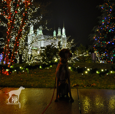
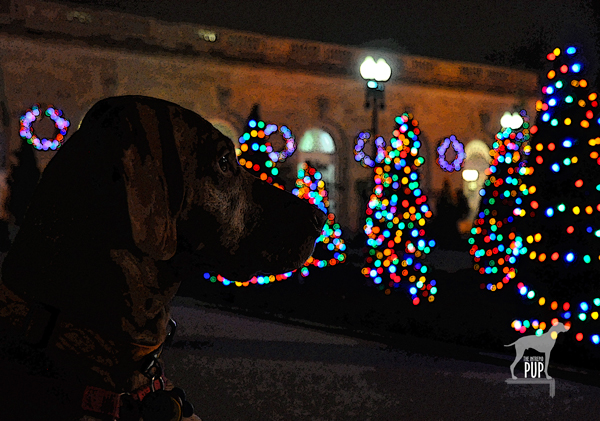
Even raindrops can’t keep Tavish from basking in the glow of 600,000 lights at the Washington D.C. Temple.


Tavish the Intrepid Pup
continues on the howl-iday trail throughout the greater Washington metro area.  Stops so far have included the Capitol Christmas Tree and the  U. S. Botanic Garden’s “Season’s Greenings.”  Next on his itinerary:  the annual Festival of Lights at The Church of Jesus Christ of Latter-day Saints.

The site is a study in juxtapositions. Called the Washington D.C. Temple, it’s actually physically located in Kensington, Maryland. The maelstrom that is the Capital Beltway is just a stone’s throw away with more than 250,000 vehicles a day passing in the Temple’s shadow. And yet the Temple sits upon 52 beautifully wooded acres—in the midst of a residential neighborhood, really. The glistening facade of white Alabama marble looks like nothing else in the area, but it still manages to blend in harmoniously.

When it opened in 1974 it was only the 16th operating Temple; today there are  more than 140. Six spires rise to 288 feet, making this Temple the Church’s tallest. While the adjacent Visitors’ Center is free and open year-round, visitation soars during the annual Festival of Lights celebration.

Click to see what a "1" on the Wag-a-meter meansDogging the Details

39°0′56.07″N, 77°3′56.21″W
Festival of Lights, Washington D.C. Temple – The Church of Jesus Christ of Latter-day Saints, Kensington, Maryland

The 35th Annual Festival of Lights runs  from November 30, 2012 through January 1, 2013 with the lights coming on at dusk. Free concerts are offered nightly in the Visitors’ Center at 7pm and again at 8pm, with tickets available 90 minutes prior to each performance.

Tavish at the LDS Temple's Festival of Lights

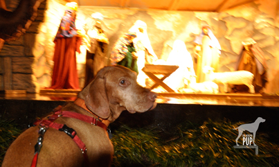
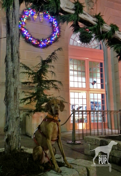
Tavish gazes upon the life-sized crèche outside the Washington D.C. Temple Visitors’ Center.

Team Tavish had the misfortune of timing this visit with a torrential downpour, so we didn’t stay nearly as long as we would have liked. The up-side to the weather, however, was that all 600,000 lights looked extra-spectacular reflecting off the drenched pavement.  Tavish wasn’t too keen about getting rained upon but kept still long enough for a few photos as we gawked at the lights and stopped at the life-sized crèche.

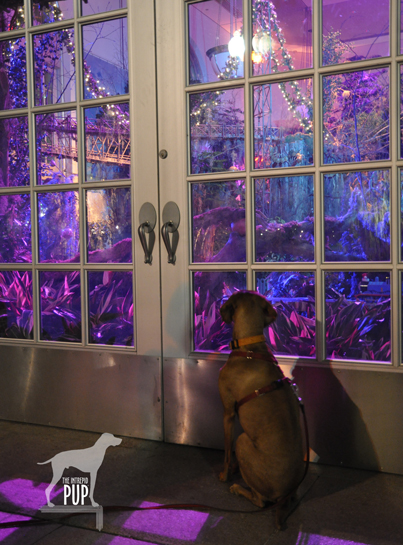
Admission to the grounds is free. Non-Mormons are not permitted in the Temple itself, but all (well, excluding dogs) are welcome in the Visitors’ Center. When we arrived, crowds of people were streaming in to hear the first concert of the evening and see the displays of decorated Christmas trees and more than 100 nativity scenes from around the world. Had the Intrepid Pup not been with us, we would have ventured in as well!

The Festival of Lights earns a “1″ on the Intrepid Pup’s wag-a-meter for illuminating the joys of the season!

Save

Save

National Howl-iday Scene: Part II

Tavish with the holiday lights at the US Botanic Garden

“Season’s Greenings” from the U.S. Botanic Garden! The colorful holiday lights outside merely hint at the wonders that lie within.

Throughout this series, Tavish the Intrepid Pup has been providing an insider’s guide to the national “howl-iday” scene. In his quest to find the most iconic—and dog-friendly—holiday spots the capital region has to offer, Tavish’s “pick of the day” is the annual Season’s Greenings display at the United States Botanic Garden. The institution falls under the auspices of the Architect of the Capitol. Dating to 1850, it has been in its present location on the wedge of land between Maryland Avenue and First Street, S.W., since 1933.

Okay, let’s just start by saying this place is beautiful year-round and is especially so during the holidays. In a city chock-a-block full of monumental and famous structures, it’d be easy to lose this one in the mix. But to do so would be a big mistake. The Botanic Garden takes the lead on horticultural education and issues of sustainable landscape design. With elaborate outdoor terraces and indoor habitats ranging from desert succulents to exotic orchids, there’s something for everyone. Not too be missed is the unique perspective from atop the canopy walk in the tropical rainforest that grows within conservatory’s 93-foot dome. And be sure to check out the magnificent Bartholdi Fountain set upon two acres of rose gardens just across Independence Avenue.

Tavish under the kissing ball at the US Botanic Garden

Will sit for kisses: Tavish has strategically planted himself beneath the mistletoe on the northeast terrace.

Click to see what a "1" on the Wag-a-meter meansDogging the Details

38°53′17.90″N, 77°0′45.46″W
United States Botanic Garden’s “Season’s Greenings”, Washington, DC

Season’s Greenings is on display from late November through early January; check website for exact dates. Admission is free.

Pups aren’t allowed inside the Botanic Garden’s buildings, but fortunately you can lap up pretty good views of Season’s Greenings by peering through the conservatory’s picture windows after dark. One glimpse of the Enchanted Forest in the east gallery is enough to make you want to return on your own to explore inside.

Tavish looking at the train display at the US Botanic Garden

Tavish gazes longingly into the “Enchanted Forest,” just one part of the Season’s Greenings display. Model trains, decorated trees, and fairytale lighting make this a feast for the senses.

Planning for Season’s Greenings takes nearly a year, with the Enchanted Forest alone requiring approximately three weeks to install. It shows in the details. A carpet of poinsettias in 17 varieties. A towering 24-foot tree—one of the largest indoor decorated trees in the region. Eight hundred feet of track for the model railway. A line-up of live music on select evenings. And a mind-boggling assortment of DC landmarks created in miniature and entirely from natural plant materials!

Parking out in front of the Botanic Garden or at meters off Independence Avenue shouldn’t prove too difficult after hours. What’s more, it’s a “two-fer”: soak in the splendor of the lighted gardens and then make the three-minute  stroll across the street to take in the Christmas tree on the west lawn of the U. S. Capitol (read the Intrepid Pup’s earlier account here).

A trip to the grounds of the Botanic Gardens earns a “1″ on the Intrepid Pup’s wag-a-meter as a free and pretty spectacular photo opp for you and your intrepid pup!

Apro-Poe of Halloween

Poe gravesite

A raven marks the spot: Tavish lurks in the shadows behind the monument indicating where Edgar Allan Poe was originally interred.

As the literary master of the dark and dreary, Edgar Allan Poe (1809-1849) and his special brand of Gothic fiction tie in conveniently with the whole Halloween oeuvre. So, on this All Hallows’ Eve, allow Tavish the Intrepid Pup to take you on a virtual visit to Poe’s grave site in Maryland.

Several cities lay legitimate claims to Poe—Boston, New York, Richmond, and Philadelphia among them. Yet, it’s Baltimore where Poe not only lived with relatives in the early 1830s but also where he ultimately died under somewhat mysterious circumstances…turning what was to have been a brief stopover in October 1849 into an eternal one.

At the heart of downtown Baltimore and today encircled by the University of Maryland School of Law are the Westminster Hall Burying Grounds and Catacombs. Despite the name, these catacombs are nowhere near as creepy as the ones that figure in Poe’s own tale, The Cask of Amontillado. The burial grounds date to the late 1700s, and the 1852 church on the site—sans congregation—is now used for private event rentals.

Poe's final resting place

Poe’s final resting place at Westminster Hall Burying Grounds. There’s no Poe Toaster in sight…unless it’s the Intrepid Pup!?!

The cemetery is actually home to not one but two Poe memorials. Proceed to the rear of the cemetery to see Poe’s initial 1849 burial plot.  While this grave never had a marker, you can’t miss the monument eventually placed there in 1913 depicting the haunting raven immortalized in Poe’s 1845 poem by the same name. On the afternoon of our visit it was particularly hot, and Tavish managed to plunk himself down in the only piece of shade, which happened to be right behind the stone and therefore created a bit of a spooky effect (see photo, right).  As the marker’s accompanying inscription indicates, Poe was exhumed in November 1875 to be re-interred in a grave with his mother-in-law/aunt Maria Clemm (1790-1871) located near the cemetery’s entrance. A decade later, the remains of Poe’s young wife/cousin Virginia (1822-1847) were transported from New York and reunited with the others in the family plot. This marble monument (see photo, left) bears all three occupants’ names, as well as a large bas-relief of Poe’s likeness.

More than two centuries later, there’s still a morbid fascination with all things Poe, and perhaps nothing epitomizes this better than the anonymous soul (or souls?) known simply as the “Poe Toaster.” Beginning in 1949 on the anniversary of Poe’s birth—and continuing for 60 years!—a man would visit the monument in the dead of night to leave a half-full bottle of cognac and three red roses.  A no-show on what would’ve been Poe’s 201st birthday heralded the end of this curious tradition, prompting local headlines to proclaim the Poe Toaster “nevermore.”

Dogging the Details

Click to see what a "1" on the Wag-a-meter means39°17′23.25″N,  76°37′23.35″W   Find it on the Intrepid Pup Map >
Westminster Hall Burying Grounds and Catacombs, Baltimore, Maryland

Literary history meets an easy bit of urban exploration to register a “1” on the Intrepid Pup wag-a-meter for this excursion.

The nearest parking garage is a block away at the Baltimore Grand (5 North Paca Street).

Upon arrival, take care in traversing the uneven brick walkways within the cemetery, and respect the grave markers. Westminster Hall offers seasonal, guided tours, but there’s a surprising amount of information to be found on various historical plaques throughout the grounds should you prefer to do a self-guided version. Spoiler alert: Poe is not the only famous historical figure buried here! Among others, look for the grave of James McHenry (1753-1816), the namesake of Baltimore’s Fort McHenry of Star Spangled Banner fame.

There Be Dragons!

Tavish at Deal's Gap's Tail of the Dragon

Tavish seemingly not intimidated by the Tail of the Dragon with a motorcycle in its clutch.

Tavish the Intrepid Pup‘s therapy dog vest sports several pins, many of which represent places he’s traveled. Mostly they’re conversation starters, and by far the one that attracts the greatest attention—primarily from kids—is the Day-Glo yellow one shaped like a road sign bearing the silhouette of a dragon and the words, “At the Gap there be dragons.” Here’s the backstory:

Last July, Tavish and Team Tavish were visiting friends in Tennessee who were eager to show us the Tail of the Dragon. It’s a storied stretch of Highway 129 that straddles the border of Tennessee and North Carolina. More accurately, it’s 318 curves in 11 miles with up to a 12% grade and 1800 feet in elevation. Hence the vivid and apt comparison to a jagged dragon’s tail. Were it a TV commercial, it’d have that impossibly fine print flickering across the bottom of the screen saying, “Do not attempt. Professional driver on a closed course.” Indeed, there have been vehicle performance tests done here, and for obvious reasons, the road is a magnet for motorcycle and sports car enthusiasts.

We had visions of “slaying the dragon” Easy Rider-style, with a Doggles®-wearing Intrepid Pup in a cool sidecar. The biggest problem with this plan was that neither we nor our friends own motorcycles. So, we did this trip in decidedly less hip fashion in what was probably an affront to the road itself: our friends’ 2001 Hyundai Elantra. Eat your heart out, James Dean.

Deal's Gap Motorcycle Resort's Tree of Shame

Who says that kinetic, post-modern sculpture can only be found in chic art galleries? Deal’s Gap has a pretty good example with its “Tree of Shame.”

Our friend drove and would periodically concede to the far more intrepid bikers by easing into paved pull-offs, earning us many appreciative nods and an occasional wave. It was also blisteringly hot that day, so the Intrepid Pup was favoring the Elantra’s AC vents over lolling out the window. But even without a white-knuckled Nürburgring experience, this was still a drive we’re glad we did.

There are a handful of entrepreneurial outfits that station photographers along the Tail of the Dragon. The business model is akin to having your photo taken at an amusement park while on some giant roller coaster and then having the opportunity to purchase said photo as you exit the ride. (Editor’s note: We did go online afterwards and easily found ourselves in that day’s batch of pictures…after all, there aren’t exactly zillions of silver Elantras amid the supercars and slick Harley-Davidsons. And, as you might’ve guessed, our souvenir car shot is best left to your imagination.)

Rounding the final curves and easing down that last slope (Wheelie Hill), reward you with the gateway attraction that is Deal’s Gap. Touting its own special brand of self-proclaimed “two-lane tourism,” Deal’s Gap consists of Tail of the Dragon LLC (an outlet store and de facto visitor information center) on one side of the highway and Deal’s Gap Motorcycle Resort (with accommodations, a shop, and a 65-seat pub) on the other.

Deal's Gap statuaryThere are two standouts in this spectacle. One is the signature green “tail” pictured above. The other is the Tree of Shame  located in the motorcycle resort’s parking lot. This crowd-sourced totem is part whimsy, part rite-of-passage, and part cautionary tale. Basically it’s 20+ years of jetsam—smashed reflectors, blown tires, broken headlights, dented hubcaps, and shorn fenders—lobbed in frustration by those unlucky enough to have been “bitten by the dragon.”  The tree is always in flux as pieces get added or otherwise shift among the branches (a nearby sign warns, “CAUTION: Watch for falling parts from Tree of Shame”). It’s also a good reminder that riding the Tail of the Dragon carries an inherent risk; over the past 12 years, there’s been an average of slightly more than two deaths a year.

The parking lot is better than any showroom for gawking at the bikes, and it was here that Tavish made a few new friends. He plunked down in the shade by a random, concrete statue (doorstop?) of a bikini- and bandanna-clad biker and drew his fair share of affectionate pats from bikers returning to their rides. Many intended to traverse the route several times that day, and one biker nostalgically reminisced to us about his own pup that he never wanted to be away from for too long.

Maybe, just maybe, Tavish will get that ride in a sidecar yet!

Dogging the Detaihttp://tailofthedragon.com/index.htmlls

Click to see what a "1" on the Wag-a-meter means

35°27′59.77″N,  83°55′9.99″W
Highway 129
(a.k.a. Tail of the Dragon),  Tennessee/North Carolina, with a stop at Deal’s Gap

35°18′22.87″N,  84°00′46.45″W
Cherohola Skyway (Routes 143/165), North Carolina/Tennessee

This excursion rates a “1” on the Intrepid Pup wag-a-meter. It was a fun, scenic outing and, aside from the driving, was not very strenuous…particularly if you’re a dog! In all, we covered 113 miles that afternoon, but this represented three hours of actual driving time, because speed limits are just 30 mph on the Tail of the Dragon and 40 mph on the Cherohala Skyway.

Cherohala Skyway

The Cherohala Skyway is the “mile-high legend.” Tavish proves it by standing at the Santeetlah Overlook, the route’s highest elevation at 5390 feet.

We had started out just south of Knoxville, snaking southeast on the Tail of the Dragon. En route we passed the Cheoah Dam. Besides holding back the water of the Little Tennessee River, it’s also famous for being the dam from which Dr. Richard Kimble—portrayed by actor Harrison Ford—swans dives in the 1993 thriller The Fugitive. It wasn’t easy for us to pull off the road right then, so there’s no Intrepid Pup photo…you’ll just have to take our word for it. We decided to extend our drive by daisy-chaining from the Tail of the Dragon right onto the Cherohala Skyway, a 60-mile, high-elevation road running west from Robbinsville, North Carolina, to Tellico Plains, Tennessee. But be sure to top off your fuel tank at Deal’s Gap as there are no gas stations on this segment. The route takes its name from the two national forests (Cherokee and Nantahala) it transects.

We made a couple stops along the Skyway to check out some pretty amazing vistas. From the sheer elevation, it’s easy to see why much of the highway gets closed during wintry weather.  Before a passing thunderstorm hit, we were also able to stretch our legs and get in a short 0.75-mile hike with Tavish along a roadside trail with interpretive signs about railroads and timber harvesting.

Save

Lest We Forget

Arlington National Cemetery: Tomb of the Unknowns

From a distance, Tavish witnesses the ceremony underway at the Tomb of the Unknowns. Sentinels from the Third U.S. Infantry headquartered at Fort Myer maintain a round-the-clock vigil. Guard changes occur every hour (and every 1/2 hour from April 1 through September 30) with a somber ritual.

UPDATE: As of October 26, 2016, Arlington National Cemetery no longer permits leashed dogs, except for service animals and military working dogs.

The last place you’d expect to find serenity is among vacationing families, high school field trippers, and trams loaded with tourists. And you’d be right…except this is Arlington National Cemetery. Even without the discreet signage to “conduct yourself with propriety,” most folks inherently realize that this is a place of honor. As such, you might pick up on the fact that there’s no recreational jogging or cycling on the grounds, and a general hush prevails. It’s a place that is at once peaceful but solemn, heroic yet tragic, both beautiful and brittle.

You don’t see many dogs at Arlington National Cemetery, though they are expressly permitted (see “Dogging the Details” below). Not to anthropomorphize, but Tavish our Intrepid Pup clearly picks up on the vibe during our visits that these are times for calm and respect. Usually most content only when his leash is fully extended, here—and without command—Tavish invariably sticks at a close heel.

We initially avoid the bulk of the crowds by walking up the steeply sloping Custis Walk. It winds by the grave of President William H. Taft as well as past the tomb of Mary Randolph, the first person known to be buried at Arlington. At the top of the hill are two memorable sights: Arlington House and a stunning panoramic view across the Potomac River of Washington, DC’s downtown monuments.

Arlington House: The Robert E. Lee Memorial

Maintained by the National Park Service, Arlington House is in the final phase of a multi-year restoration. The building is currently unfurnished, with certain rooms closed to the public, but visitors are encouraged to take a self-guided tour.

Quite simply, were it not for Arlington House, there would be no Arlington National Cemetery. The Greek temple-style house was constructed in 1802 by George Washington Parke Custis (1781-1857), who had been raised from infancy at Mount Vernon by none other than his grandmother Martha (Custis) Washington and her second husband George Washington. Custis intended for Arlington House to be both a family home and a tribute to his illustrious step-grandfather. Further cementing its place in history was the 1831 wedding in the parlor of Custis’s daughter Mary Anna Randolph Custis and Lt. Robert E. Lee, son of Revolutionary War Hero Henry “Light-Horse Harry” Lee. The marriage united two prominent Virginia families. When Virginia seceded from the Union on April 19, 1861, Robert E. Lee resigned his commission from the U.S. Army the next day and sided with his home state. Lee’s decision not only inexorably altered the course of the American Civil War but also cost him his home. To defend the nation’s capital, Union troops made preparations to occupy the strategically situated Arlington House. The Lee family left in haste in May 1861, and when Lee’s wife failed to pay property taxes in person, the home was confiscated. Government officials—interpreting Lee’s loyalty to Virginia as an act of treason—further sought to ensure against the Lees’ return by establishing a military cemetery on their land.  Lee’s uprooted family would never again live at Arlington House, and Arlington National Cemetery was born.

Tavish at Arlington National Cemetery

Tavish on the Custis Walk at Arlington National Cemetery, overlooking the eternal flame at President John F. Kennedy’s grave.

Roads through the cemetery are named almost entirely for American military heroes (Pershing, Nimitz, MacArthur, Eisenhower, etc.). Following them takes you on an introspective journey among the cemetery’s more than 250,000 graves. If you’re of a certain age, the memorials for the crews of Space Shuttles Challenger and Columbia will hold special meaning. And if you’re of another certain age, the eternal flame marking the grave of President John F. Kennedy will take you back to that fateful day in Dallas. Then there’s the main mast of the U.S.S. Maine, erected in the memory of those who died in the explosion in Havana Harbor in 1898. Individual headstones honor the final resting places of veterans who also distinguished themselves in other arenas—folks like heavyweight boxing champion Joe Louis, Supreme Court Chief Justice William Rehnquist,  polar explorer Richard Byrd, and astronaut Gus Grissom. The iconic Memorial Amphitheater provides the backdrop for the Tomb of the Unknowns, and the changing of the guard ceremony will leave a lump in your throat no matter how many times you see it. Further afield is the Pentagon Group Burial Marker, a five-sided black granite memorial to those who died in the Pentagon or on American Airlines Flight 77 during the terrorist attacks of September 11, 2001.

It was here, on our most recent visit (this very Memorial Day weekend), that we were joined by a small group who had just pulled up on their Harley-Davidsons. One middle-aged women initiated conversation, explaining that she was in town for the Memorial Day Rolling Thunder activities that heighten awareness for POW/MIAs. “Best thing I’ve ever done,” she said. She gestures in the direction of another woman, clad in a white leather biker jacket. “Do you see that lady there?” she asked. “She’s a gold star mother. Her son died in Iraq in ’03. We just came from visiting his grave.” She tugged at the back of her own leather jacket to show us the patch that all her chapter members wear in his memory. A sobering moment.

And then there is Section 60.

The tenor of the cemetery perceptibly changes here from past to present. It’s the only area in Arlington National Cemetery where placing mementos beyond traditional flowers is officially sanctioned. Here you see snapshots propped up against the headstones. Candles spelling out “Happy Birthday.” A tethered heart-shaped balloon emblazoned with “I Love You.” Here the emotional scars are still as raw as the ground where grass has yet to grow over, where—in some instances—a permanent marker has yet to be placed. The standard signage seen elsewhere in the cemetery gives way here to signs that read simply, “Funeral Route.” Removed from the throngs is where Arlington is experienced at perhaps its most profound. Here is where the nation’s war dead from Afghanistan are being buried.

Oddly, your visit to Arlington up to this point isn’t quite adequate preparation for the visceral reality of Section 60, and it hits you like the proverbial ton of bricks. Ahead on the path, several rows in, we noticed a woman (a wife? mother? sister?) standing stock still before a grave where she had spread what appeared to be a red, white, and blue handmade quilt. We maintained a respectful distance so as not to intrude, and she was unaware of our presence. Yet, just as we were about to pass, she stirred, and in one fluid movement lay down upon the quilt, curling onto her side, eyes closed in a private, unspeakable grief.

Dogging the Details

Click to see what a "1" on the Wag-a-meter means 38°52′34.59″N,  77° 4′13.83″W
Arlington National Cemetery, Arlington, Virginia

38°52′51.92″N,  77° 4′20.91″W
Arlington House: The Robert E. Lee Memorial
, Arlington, Virginia

Arlington National CemeteryFor as many times as we’ve visited Arlington National Cemetery over the years, it wasn’t until a friend and fellow dog owner recently mentioned it, that we were aware that leashed dogs are allowed on the grounds. Unless they’re service animals, they aren’t permitted in the visitor center buildings or inside Arlington House.

The Cemetery’s accessibility earns it a “1” on the Intrepid Pup wag-a-meter. The Cemetery has its own Metrorail  stop on the blue line and is regular destination on most guided tours of the area , but if you’re coming with your pet, these aren’t options. If you’re coming on foot, you can reach the Cemetery’s main entrance from the pedestrian trails that run over the Memorial Bridge and along Route 110 and the George Washington Memorial Parkway. Your best bet, however, is simply to park onsite at the Cemetery. There is ample vehicle parking in the paid lot off Memorial Drive, and rates are quite reasonable (currently, $1.75/hour for the first three hours and $2.50/hour thereafter). There is no admission fee to the Cemetery or to Arlington House. Once on the grounds, the Cemetery is extremely walkable, with well-marked paved drives and posted locator maps. Maps are also available from the visitors center. Be mindful that much of the cemetery’s 624 acres is hilly (“Uphill in both directions!” we overheard one family remark), so plan accordingly and bring plenty of water for yourself and your dog. Temperatures, particularly in the summer months, routinely exceed 80 degrees. Though the sheer expanse of the grounds readily absorbs crowds, Arlington National Cemetery attracts upwards of 4 million visitors annually, so be prepared for lots of people at popular locations like the Tomb of the Unknowns.


Save