
OBX: three little letters stand for North Carolina’s Outer Banks and a summer full of fun for dogs and people alike. Many locations along the Outer Banks are denoted simply by their milepost number along U.S. Highway 158. At Whalebone Junction, the road becomes a decidedly less-congested N.C. Route 12 and is the gateway to Cape Hatteras, designated the country’s first national seashore in 1953. Beaches are dog-friendly, with regulations varying by town and season. Here are the Intrepid Pup’s picks for the top five scenic and sandy spots at this east coast playground:
After wandering the grounds, be sure to follow the 1/8-mile boardwalk through the marsh for a picture-perfect view.
35° 49′ 5.30″ N, 75° 33′ 51.53″ W
Bodie Island Light Station, Bodie Island, Cape Hatteras National Seashore, North Carolina
Open March – DecemberThroughout the centuries, the storms and shoals defining this stretch of coastline have wrecked more than 600 ships. Were it not for the area’s lighthouses and lifesaving services, this Graveyard of the Atlantic would have claimed even more. Don’t miss Bodie Island Light Station, the 164.4-foot black and white striped beacon whose light is visible from 19 miles at sea. Constructed in 1872, it’s actually the third light station to occupy that approximate location. Since 2000, it’s been maintained by the National Park Service, and you can even take a ranger-led tour up the tower. While dogs aren’t currently allowed inside the light station, that wasn’t always the case. A Chesapeake Bay Retriever named Chess used to climb the tower every day, accompanying his master Vernon Gaskill who served as Bodie Island’s last civilian-era keeper (1919-1939). According to Elinor De Wire’s book, The Lightkeepers’ Menagerie—on sale in the light station’s gift shop—Chess had no problem with the heights but apparently drew the line at entering the lantern room, because he didn’t like the odor of kerosene!

The emptiness here adds to the mystery and kind of proves a point. After all, it is the Lost Colony.
35° 56′ 9.79″ N, 75° 42′ 35.35″ W
Fort Raleigh National Historic Site, Roanoke Island, North Carolina
Open year-roundA newly renovated visitor center at this National Park Service site interprets the history of Roanoke Island, from Algonquian homeland in the 1500s to a refuge for runaway slaves during the Civil War. But the spot is perhaps best known for what it wasn’t, namely a successful English colony. In fact, no one knows for certain what became of the English settlers who’d arrived in 1587. When Governor John White returned to check on his transplants to the New World three years later, the 117 colonists plus White’s ill-fated granddaughter Virginia Dare (the first baby born to English settlers in Virginia) seemed to have vanished into thin air. An abandoned fort and the word “CROATOAN” carved into a post are the scant clues in this unsolved mystery.
You, too, can explore the grounds of the lost colony. Pass a reconstructed version of the original earthen fort and join up with the Hariot Nature Trail for what amounts to about a 20-minute walk. We came upon a flock of ibises unhurriedly picking their way through the clearing. The wooded trail is slightly overgrown in spots and is punctuated by markers identifying types of trees and habitats. Sprinkled in are quotes drawn from accounts in Old English affirming the myriad challenges that the colonists faced. The trail provides a picturesque view of Albemarle Sound before circling back to the Visitor Center. Let us know if you happen to make the separate 2.5-mile round-trip hike on the Freedom Trail out to Croatan Sound—we were unfortunately thwarted in our attempt by a severe thunderstorm!

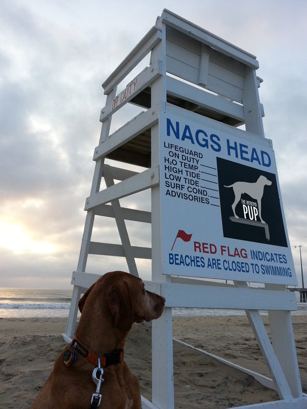
The Intrepid Pup officially “off duty” on the beaches of Nags Head.
35° 54′ 36.32″ N, 75° 35′ 43.77″ W
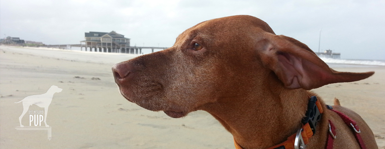
Nags Head Beaches & Jennette’s Pier, Nags Head, North Carolina (milepost 16.5)Cape Hatteras National Seashore and the towns of Duck, Kill Devil Hills, Kitty Hawk, Nags Head, and Southern Shores all permit dogs on their beaches with varying degrees of seasonal access and leash laws. Team Tavish and the Intrepid Pup particularly like the beaches in Nags Head, because dogs are allowed on the beach year-round and at any time of day so long as they are on a maximum 10-ft leash and owners clean up.
A bronze sea turtle stands watch by the pier house on Jeannette’s Pier.
While Tavish loves the water, he isn’t big on swimming, and that’s actually just fine here, because one does have to be mindful of the dangerous rip currents that can lurk offshore. But the beaches are clean and wide…perfect for an Intrepid Pup to snuffle the sand, poke at shells, crabs and seaweed, and skitter through the foamy surf. Walk the beach at sunrise and you’re sure to catch glimpses of skimming pelicans and playful porpoises offshore. Hard to miss at the heart of the beach’s Whalebone District is Jennette’s Pier (see photo at top). It’s been at this location since 1939, and its current iteration is all concrete and extends 1,000 feet into the Atlantic Ocean. Dogs aren’t permitted in or beyond the pier house, but you can get as far as the oversize bronze sculpture of a sea turtle. From that vantage point you can watch all the anglers heading out onto the pier to catch bluefish, cobia, skate, pigfish, mackerel, sea mullet, and more.

The dunes at this state park are very cool…just be mindful of your dog’s paws, because the sand can get hot, hot, HOT!
35° 57′ 50.37″ N, 75° 37′ 59.38″ W
Jockey’s Ridge State Park, Nags Head, North Carolina (milepost 12)
Open year-round
Did you know that this 420-acre state park represents the eastern United States’ largest natural dune system? It’s open to the public year-round, though park hours vary by season. Parking and general access are free. Dogs are allowed, so long as they remain on 6-foot leashes. From the visitor center, you can stroll a 360-foot boardwalk to a dune overlook, set out on the 1.5-mile “Tracks in the Sand” interpretive trail, take a mile-long walk on the “Soundside” nature trail…or simply scale the dunes. The shifting sands create a ridge that varies in height from 80 to 100 feet, providing spectacular views of the Atlantic Ocean and Roanoke Sound. With fairly steady prevailing winds, Jockey’s Ridge is a favorite destination for kiteboarders and sandboarders. On the morning of our visit, hang gliding lessons were just getting underway, and the park was also gearing up for a big kite festival. We’d been forewarned that the sand at Jockey’s Ridge can get anywhere from 10 to 30 degrees hotter than the air temperature, so Tavish came prepared wearing his Ruffwear Swamp Cooler™ vest (a real godsend that made all the difference in his comfort in the dry heat), and he had his protective paw booties at the ready. A word to the wise: try taking off your shoes. If it’s too hot to walk on the dunes barefoot, it’ll definitely be too hot for your pup! When we reached the ridge, the radio announcer for the kite festival approached us to pet Tavish. Taking stock of all of our water bottles and gear, he remarked, “Wow, I can’t tell you how many people I see come up here with no water for themselves, let alone for their dogs. Big mistake.”

The sky’s the limit at the Wright Brothers National Memorial!
36° 0′ 51.20″ N, 75° 40′ 4.40″ W
Wright Brothers National Memorial, Kill Devil Hills, North Carolina (milepost 7.5)
Open year-round
Modern aviation is indebted to two Ohio brothers who journeyed to what at the turn-of-the 20th century was a remote patch of dunes. Carefully chosen for the winds, lack of distractions, and sandy landings, Kill Devil Hills was where Orville and Wilbur Wright first achieved powered, controlled, and sustained human flight on December 17, 1903. You can follow in the brothers’ flight path with a visit to this National Park Service memorial. With Tavish in tow, we covered a total of approximately 1.5 miles walking the grounds. A pathway with stone markers traces the trajectories and landings of the Wrights’ first four powered flights. Trek uphill to get a panorama of the site, topped by a 60-foot granite memorial; it’s the same promontory from which the Wrights had earlier experimented with glider flights. Before turning back to further explore the informative Visitor Center, head downhill beyond the memorial. At the apex of the trail loop is a bronze and stainless steel sculpture group entitled, December 17, 1903. It captures the same instant of first flight as the iconic photograph and makes for a pretty nifty photo opp all its own!

Dogging the Details
 You see a lot of dogs on the Outer Banks enjoying outdoor activities a-plenty. So at first we were puzzled by the fact that dog-friendly lodging and dining weren’t as abundant. It turns out that many dog-owning OBX vacationers rent beach houses by the week (Sunday to Saturday) so they’re not needing as many hotels and always have the option of cooking in. That being said, there are approximately a dozen pet-friendly overnight accommodations. We stayed at the Dolphin Oceanfront Motel (milepost 16.5), finding it to be minimalist but functional, with its key attribute being that it had a primo location right on the beach. By no means inexpensive, it was still comparatively less pricey than the pet-friendly rooms at the national hotel chains and some of the local B&Bs.

Chillaxing at the Front Porch Cafe
Foodwise, we stopped at a couple places with patio dining only to discover that dogs weren’t allowed. We hit the jackpot, though, in finding the Front Porch Cafe for breakfast. We ate at their locations in Nags Head (milepost 10.5) and Kill Devil Hills (milepost 6). In addition to making a good cup o’ joe, they have a wide assortment of muffins, pastries, and breakfast sandwiches. We sat outside in roomy Adirondack chairs, and the staff was quick to offer Tavish dog biscuits and a bowl of water. Pigman’s Bar-B-Que was our other find. We took our order out to their picnic tables, and Tavish happily sampled our Carolina-style Que, hush puppies, fries, slaw, baked beans, and cornbread. OBX ranks a “2” on the Intrepid Pup’s wag-a-meter for providing enough canine fun in the sun, sand and surf to blow Tavish’s ears back! Grab a leash and go!
 If you’ve always associated Maine with craggy shorelines, there are plenty. But you might be surprised to learn that beautiful sandy beaches can be found in coastal towns throughout southern Maine. One favorite is Kennebunk Beach. At low tide, this crescent-shaped swath of sand extends out about a hundred yards before receding into the Atlantic Ocean. Then, if you could even see this far, the next land you’d spot would be Portugal. Seriously. The surrounding communities, collectively known as the Kennebunks, are tourist magnets (particularly in the summer and fall), but Kennebunk Beach holds a year-round allure even after temperatures for swimming and sun-bathing are but distant memories. The sidewalk follows the shoreline and is great for dog-walking, complete with several waste receptacles and doggie-bag dispensers. In fact, this same scenic route along the seawall is used by the area’s Animal Welfare Society for its insanely popular (and fun) annual “Strut Your Mutt” fundraiser.
 Team Tavish dug back into the Intrepid Pup archives for this pic of an approximately 11-week-old Tavish on one of his very first trips to what would become a frequent destination: Peaks Island. Of the several hundred island communities that dot Casco Bay, Peaks is the most populous with ~1,100 year-round residents, though that number swells to 4,000+ during the summer months. Peaks is actually part of the City of Portland, but its history has been punctuated by various—and as yet, unsuccessful—secessionist movements. It’s accessible via a 15-minute ride from downtown Portland on the Casco Bay Lines
  Camden